Comayagua Department: Difference between revisions
Appearance
Content deleted Content added
→Municipalities: made this section three columns. added ref section |
|||
| Line 9: | Line 9: | ||
==Economy== |
==Economy== |
||
Historically, the department produced [[gold]], [[copper]], [[cinnabar]], [[asbestos]], and [[silver]]. [[ |
Historically, the department produced [[gold]], [[copper]], [[cinnabar]], [[asbestos]], and [[silver]]. [[Gemstone|Gems]] were also mined, including [[opal]] and [[emerald]]. The area was also known for "fine" [[cattle]].<ref name=Baily>{{cite book|last=Baily|first=John|title=Central America; Describing Each of the States of Guatemala, Honduras, Salvador, Nicaragua, and Costa Rica|year=1850|publisher=Trelawney Saunders|location=London|pages=128-129|url=http://www.wdl.org/en/item/7306/view/1/128/}}</ref> |
||
==[[Municipalities of Honduras|Municipalities]]== |
==[[Municipalities of Honduras|Municipalities]]== |
||
Revision as of 15:23, 3 October 2013

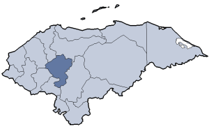
Comayagua (Spanish pronunciation: [komaˈʝaɣwa]) is one of the 18 departments (departamentos) into which the Central American nation of Honduras is divided. The departmental capital is Comayagua.
Geography
The department covers a total surface area of 5,196 km² and, in 2005, had an estimated population of 390,643 people.
Economy
Historically, the department produced gold, copper, cinnabar, asbestos, and silver. Gems were also mined, including opal and emerald. The area was also known for "fine" cattle.[1]
References
- ^ Baily, John (1850). Central America; Describing Each of the States of Guatemala, Honduras, Salvador, Nicaragua, and Costa Rica. London: Trelawney Saunders. pp. 128–129.
