Villeveyrac: Difference between revisions
Appearance
Content deleted Content added
image |
Caption added in Infobox |
||
| Line 2: | Line 2: | ||
|name = Villeveyrac |
|name = Villeveyrac |
||
|image = Villeveyrac, Hérault 01.jpg |
|image = Villeveyrac, Hérault 01.jpg |
||
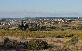
|caption = General view from East |
|||
|region = Languedoc-Roussillon |
|region = Languedoc-Roussillon |
||
|department = Hérault |
|department = Hérault |
||
Revision as of 07:49, 28 November 2013
Villeveyrac | |
|---|---|
 General view from East | |
| Country | France |
| Region | Occitania |
| Department | Hérault |
| Arrondissement | Montpellier |
| Canton | Mèze |
| Intercommunality | Nord du Bassin de Thau Bassin de Thau |
| Government | |
| • Mayor (2008–2014) | Alain Jeantet |
Area 1 | 37.12 km2 (14.33 sq mi) |
| Population (2008) | 2,905 |
| • Density | 78/km2 (200/sq mi) |
| Time zone | UTC+01:00 (CET) |
| • Summer (DST) | UTC+02:00 (CEST) |
| INSEE/Postal code | 34341 /34560 |
| Elevation | 12–255 m (39–837 ft) (avg. 75 m or 246 ft) |
| 1 French Land Register data, which excludes lakes, ponds, glaciers > 1 km2 (0.386 sq mi or 247 acres) and river estuaries. | |
Villeveyrac is a commune in the Hérault department in the Languedoc-Roussillon region in southern France.
Population
| Year | Pop. | ±% |
|---|---|---|
| 1962 | 1,571 | — |
| 1968 | 1,609 | +2.4% |
| 1975 | 1,618 | +0.6% |
| 1982 | 1,686 | +4.2% |
| 1990 | 1,842 | +9.3% |
| 1999 | 2,211 | +20.0% |
| 2008 | 2,905 | +31.4% |

