Buitenpost: Difference between revisions
Appearance
Content deleted Content added
No edit summary |
|||
| Line 28: | Line 28: | ||
== Gallery == |
== Gallery == |
||
<gallery> |
<gallery> |
||
File:Buitenpost, de Mariakerk RM7036 foto4 2013-08-25 14.30.JPG| |
File:Buitenpost, de Mariakerk RM7036 foto4 2013-08-25 14.30.JPG|Church: de Mariakerk |
||
File:Buitenpost, standbeeld en pizzeria foto2 2013-08-25 14.24.JPG| |
File:Buitenpost, standbeeld en pizzeria foto2 2013-08-25 14.24.JPG|Statue and pizzeria |
||
File:Buitenpost, uitzendbureau in monumentaal pand foto5 2013-08-25 14.20.JPG| |
File:Buitenpost, uitzendbureau in monumentaal pand foto5 2013-08-25 14.20.JPG|Employment agency in monumental building |
||
</gallery> |
</gallery> |
||
Revision as of 21:30, 24 December 2013
Buitenpost | |
|---|---|
Village | |
 | |
| Country | |
| Province | |
| Population | |
• Total | 5,834 (1 january 2,012) |
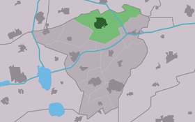
Buitenpost (Bûtenpost in West Frisian) is a town in north-east Friesland in the Netherlands.
It lies approximately halfway between the cities of Leeuwarden (the capital of Friesland) and Groningen, in the northern part of the municipality of Achtkarspelen. With 5,765 inhabitants, Buitenpost is the second largest settlement in the municipality.
Buitenpost is home to the Netherlands' largest botanical herbal garden
More information on Buitenpost and its inhabitants can be found on the site of the local community-organization www.binnenbuitenpost.nl
Notable buildings
Gallery
-
Church: de Mariakerk
-
Statue and pizzeria
-
Employment agency in monumental building


