Maguarichi Municipality: Difference between revisions
Appearance
Content deleted Content added
m Bot: Migrating 5 interwiki links, now provided by Wikidata on d:q2656449 (Report Errors) |
update population from 2010 census, ref |
||
| Line 86: | Line 86: | ||
|area_blank1_sq_mi = |
|area_blank1_sq_mi = |
||
<!-- Population -----------------------> |
<!-- Population -----------------------> |
||
|population_as_of = |
|population_as_of =2010 |
||
|population_footnotes = |
|population_footnotes = |
||
|population_note = |
|population_note = |
||
|population_total = |
|population_total =1,921 |
||
|population_density_km2 = |
|population_density_km2 =auto |
||
|population_density_sq_mi = |
|population_density_sq_mi = |
||
|population_metro = |
|population_metro = |
||
| Line 127: | Line 127: | ||
''' Maguarichi ''' is one of the 67 [[municipalities of Chihuahua]], in northern [[Mexico]]. The municipal seat lies at [[Maguarichi]] village. The municipality covers an area of 937.2 km². |
''' Maguarichi ''' is one of the 67 [[municipalities of Chihuahua]], in northern [[Mexico]]. The municipal seat lies at [[Maguarichi]] village. The municipality covers an area of 937.2 km². |
||
As of |
As of 2010, the municipality had a total population of 1,921,<ref name=SEDESOL>{{cite web|title=Maguarichi|url=http://www.microrregiones.gob.mx/catloc/LocdeMun.aspx?tipo=clave&campo=loc&ent=08&mun=041|work=Catálogo de Localidades|publisher=[[Secretaría de Desarrollo Social]] (SEDESOL)|accessdate=23 April 2014}}</ref> down from 2,116 as of 2005.<ref>{{cite web|title=Maguarichi|url=http://www.e-local.gob.mx/work/templates/enciclo/chihuahua/Mpios/08041a.htm|work=Enciclopedia de los Municipios de México|publisher=[[Instituto Nacional para el Federalismo y el Desarrollo Municipal]]|accessdate=October 13, 2008}}</ref> |
||
The municipality had 158 localities, none of which had a population over 1,000.<ref name=SEDESOL/> |
|||
==Geography== |
==Geography== |
||
| Line 134: | Line 136: | ||
{| class="wikitable" |
{| class="wikitable" |
||
|- style="background:#000000; color:black;" |
|- style="background:#000000; color:black;" |
||
! '''Name''' !! '''Population''' |
! '''Name''' !! '''Population (2005)''' |
||
|- |
|- |
||
| [[Maguarichi]] || 751 |
| [[Maguarichi]] || 751 |
||
Revision as of 20:13, 12 May 2014
Maguarichi | |
|---|---|
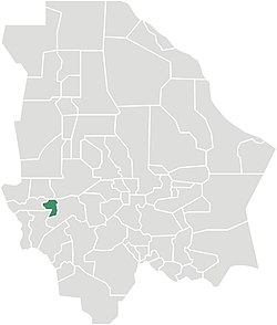
 Municipality of Maguarichi in Chihuahua | |
| Country | |
| State | Chihuahua |
| Municipal seat | Maguarichi |
| Area | |
• Total | 937.2 km2 (361.9 sq mi) |
| Population (2010) | |
• Total | 1,921 |
| • Density | 2.0/km2 (5.3/sq mi) |
Maguarichi is one of the 67 municipalities of Chihuahua, in northern Mexico. The municipal seat lies at Maguarichi village. The municipality covers an area of 937.2 km².
As of 2010, the municipality had a total population of 1,921,[1] down from 2,116 as of 2005.[2]
The municipality had 158 localities, none of which had a population over 1,000.[1]
Geography
Towns and villages
The municipality has 84 localities. The largest are:
| Name | Population (2005) |
|---|---|
| Maguarichi | 751 |
| Ocoviachi | 241 |
| San José de las Lajas | 93 |
| Total Municipality | 2,116 |
References
- ^ a b "Maguarichi". Catálogo de Localidades. Secretaría de Desarrollo Social (SEDESOL). Retrieved 23 April 2014.
- ^ "Maguarichi". Enciclopedia de los Municipios de México. Instituto Nacional para el Federalismo y el Desarrollo Municipal. Retrieved October 13, 2008.

