Encanto, Phoenix, Arizona: Difference between revisions
Appearance
Content deleted Content added
Undid revision 591764214 by Shinebright5522 (talk) Revert advertisement |
commonscat. |
||
| Line 94: | Line 94: | ||
|footnotes = |
|footnotes = |
||
}} |
}} |
||
'''Encanto Village''' is one of the 15 [[Urban village]]s that make up the [[Phoenix, Arizona|City of Phoenix]], in [[Arizona]]. |
|||
==Geography== |
|||
The community is located in Central Phoenix. |
|||
The western border of the village is the [[Interstate 17 in Arizona|I-17 Black Canyon Freeway]], and the southern border is McDowell Road. The Grand Canal makes up the northern and eastern border. |
|||
==Features== |
|||
| ⚫ | |||
Other points of interest include [[Encanto Park]], [[Steele Indian School Park]], and [[Phoenix College]]. |
|||
==External links== |
|||
{{commonscat|Encanto, Phoenix}} |
|||
| ⚫ | The core of the Encanto Village is [[Park Central Mall]] |
||
{{coord missing|Arizona}} |
{{coord missing|Arizona}} |
||
| Line 105: | Line 117: | ||
{{-}} |
|||
{{Arizona-geo-stub}} |
{{Arizona-geo-stub}} |
||
Revision as of 23:52, 28 May 2014
Encanto | |
|---|---|
| Encanto Village | |
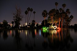
 Encanto Park at night | |
 Location of Encanto highlighted in red. | |
| Country | United States |
| State | Arizona |
| County | Maricopa |
| City | Phoenix |
| Website | Encanto Village Planning Committee |
Encanto Village is one of the 15 Urban villages that make up the City of Phoenix, in Arizona.
Geography
The community is located in Central Phoenix.
The western border of the village is the I-17 Black Canyon Freeway, and the southern border is McDowell Road. The Grand Canal makes up the northern and eastern border.
Features
The core of the Encanto Village is the Park Central Mall; and the Arizona State Fair, on whose fairgrounds the Arizona Veterans Memorial Coliseum is located. It was the original home of the Phoenix Suns, the city's NBA franchise.
Other points of interest include Encanto Park, Steele Indian School Park, and Phoenix College.
External links
Wikimedia Commons has media related to Encanto, Phoenix.
