Amt Seelow-Land: Difference between revisions
Appearance
Content deleted Content added
Stamptrader (talk | contribs) m improved translation of "den heutigen Grenzen" |
|||
| Line 9: | Line 9: | ||
== Demography == |
== Demography == |
||
<gallery widths="300" heights="250"> |
<gallery widths="300" heights="250"> |
||
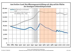
File:Bevölkerungsentwicklung Amt Seelow-Land.pdf|Development of Population since 1875 within the |
File:Bevölkerungsentwicklung Amt Seelow-Land.pdf|Development of Population since 1875 within the Current Boundaries (Blue Line: Population; Dotted Line: Comparison to Population Development of Brandenburg state; Grey Background: Time of Nazi rule; Red Background: Time of Communist rule) |
||
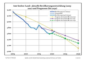
File:Bevölkerungsprognosen Amt Seelow-Land.pdf|Recent Population Development (Blue Line) and Forecasts |
File:Bevölkerungsprognosen Amt Seelow-Land.pdf|Recent Population Development (Blue Line) and Forecasts |
||
</gallery> |
</gallery> |
||
Revision as of 06:58, 16 June 2014
Seelow-Land is an Amt ("municipal federation") in the district of Märkisch-Oderland, in Brandenburg, Germany. Its seat is in Seelow, itself not part of the Amt.
The Amt Seelow-Land consists of the following municipalities:
Demography
-
Development of Population since 1875 within the Current Boundaries (Blue Line: Population; Dotted Line: Comparison to Population Development of Brandenburg state; Grey Background: Time of Nazi rule; Red Background: Time of Communist rule)
-
Recent Population Development (Blue Line) and Forecasts


