Balangestan: Difference between revisions
Appearance
Content deleted Content added
No edit summary |
m Reverted edits by 195.138.195.224 (talk) to last version by CambridgeBayWeather |
||
| Line 1: | Line 1: | ||
{{for|the village in Bushehr Province|Balangestan, Bushehr}} |
{{for|the village in Bushehr Province|Balangestan, Bushehr}} |
||
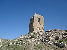
[[Image:ghalaeh balangestan.jpg|thumb|[[Ghalaeh Balangestan]] or [[Balangestan Castle]] قلعه بالنگستان فداغ ]] |
[[Image:ghalaeh balangestan.jpg|thumb|[[Ghalaeh Balangestan]] or [[Balangestan Castle]] قلعه بالنگستان فداغ ]] |
||
'''Balangestan''' ({{lang-fa|بالنگستان}}) is a garden and castle about {{convert|8|km|abbr=on}} north of [[Fedagh]] (Fidaq) in an area of good weather. Fedagh is one of the villages of [[ |
'''Balangestan''' ({{lang-fa|بالنگستان}}) is a garden and castle about {{convert|8|km|abbr=on}} north of [[Fedagh]] (Fidaq) in an area of good weather. Fedagh is one of the villages of [[Larestan County]] in the [[Fars Province]] of [[Iran]]. Balangestan is a noted tourist attraction with a service station, picnic area and free access.<ref name="balgar1">[http://mbendi.mobi/fac_view.xhtml?I=106821 Balangestan Garden]</ref><ref name="balgar2">[http://www.mbendi.com/travel/attr/106/f821.htm Balangestan Garden - Garden near Fedagh, Fars, Iran]</ref><ref name="castle">[http://www.mbendi.com/travel/attr/106/f810.htm Balangestan Castle - Castle in Fedagh, Fars, Iran]</ref> |
||
== Balangestan mountain == |
== Balangestan mountain == |
||
Balangestan mountain is a continuation of the south [[Zagros Mountains]]. It is one of the tallest mountains in |
Balangestan mountain is a continuation of the south [[Zagros Mountains]]. It is one of the tallest mountains in Larestan. |
||
There are some trees and plants such as [[Diospyros lotus|lotus]], [[Pistacia atlantica|Persian turpentine tree]], [[Thyme|garden thyme]] and [[Mentha pulegium|pennyroyal]] on the mountain that are irrigated by a local fountain. There is also animals like [[hyena]], [[Gray wolf|wolf]], [[porcupine]] and [[rabbit]] on the mountain.<ref name="balgar1"/><ref name="balgar1"/><ref name="castle"/> |
There are some trees and plants such as [[Diospyros lotus|lotus]], [[Pistacia atlantica|Persian turpentine tree]], [[Thyme|garden thyme]] and [[Mentha pulegium|pennyroyal]] on the mountain that are irrigated by a local fountain. There is also animals like [[hyena]], [[Gray wolf|wolf]], [[porcupine]] and [[rabbit]] on the mountain.<ref name="balgar1"/><ref name="balgar1"/><ref name="castle"/> |
||
== See also == |
== See also == |
||
*[[ |
*[[Lar (Iran)]] |
||
==References== |
==References== |
||
| Line 19: | Line 19: | ||
[[Category:Larestan County]] |
[[Category:Larestan County]] |
||
{{ |
{{Larestan-geo-stub}} |
||
Revision as of 20:03, 17 July 2014

Balangestan (Template:Lang-fa) is a garden and castle about 8 km (5.0 mi) north of Fedagh (Fidaq) in an area of good weather. Fedagh is one of the villages of Larestan County in the Fars Province of Iran. Balangestan is a noted tourist attraction with a service station, picnic area and free access.[1][2][3]
Balangestan mountain
Balangestan mountain is a continuation of the south Zagros Mountains. It is one of the tallest mountains in Larestan.
There are some trees and plants such as lotus, Persian turpentine tree, garden thyme and pennyroyal on the mountain that are irrigated by a local fountain. There is also animals like hyena, wolf, porcupine and rabbit on the mountain.[1][1][3]
See also
References
Wikimedia Commons has media related to Balangestan.
