Suvereto: Difference between revisions
Appearance
Content deleted Content added
metric conversion |
Added {{expand language}} tag to article (TW) |
||
| Line 1: | Line 1: | ||
{{expand language|topic=|langcode=it|otherarticle=Suvereto|date=August 2014}} |
|||
{{Infobox Italian comune |
{{Infobox Italian comune |
||
| name = Suvereto |
| name = Suvereto |
||
Revision as of 14:40, 27 August 2014
You can help expand this article with text translated from the corresponding article in Italian. (August 2014) Click [show] for important translation instructions.
|
Suvereto | |
|---|---|
| Comune di Suvereto | |
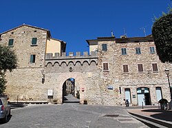
 South gate of Suvereto | |
| Country | Italy |
| Region | Tuscany |
| Province | Livorno (LI) |
| Government | |
| • Mayor | Giampaolo Pioli |
| Area | |
• Total | 92.9 km2 (35.9 sq mi) |
| Elevation | 90 m (300 ft) |
| Population (31 December 2006)[2] | |
• Total | 3,007 |
| • Density | 32/km2 (84/sq mi) |
| Demonym | Suveratani |
| Time zone | UTC+1 (CET) |
| • Summer (DST) | UTC+2 (CEST) |
| Postal code | 57028 |
| Dialing code | 0565 |
| Patron saint | Santa Croce |
| Saint day | May 3 |
| Website | Official website |
Suvereto is a comune (municipality) in the Province of Livorno in the Italian region Tuscany, located about 90 kilometres (56 miles) southwest of Florence and about 60 kilometres (37 mi) southeast of Livorno.
Technological sites
- Static inverter plant of HVDC SACOI, the HVDC-power cable connecting the power grids of Corse and Sardinia with the grid of the Italian mainland.
- Research centre for switchyards of ENEL, including an experimental 3-kilometre (1.9 mi) long powerline to Valdicciola, which is partly built as underground cable
Wikimedia Commons has media related to Suvereto.
- ^ "Superficie di Comuni Province e Regioni italiane al 9 ottobre 2011". Italian National Institute of Statistics. Retrieved 16 March 2019.
- ^ "Popolazione Residente al 1° Gennaio 2018". Italian National Institute of Statistics. Retrieved 16 March 2019.

