Kavajë District: Difference between revisions
Appearance
Content deleted Content added
No edit summary |
|||
| Line 14: | Line 14: | ||
| subdivision_type = Country |
| subdivision_type = Country |
||
| subdivision_name = {{flag|Albania}} |
| subdivision_name = {{flag|Albania}} |
||
| subdivision_type1 = Prefecture |
| subdivision_type1 = Prefecture(s) |
||
| subdivision_name1 = [[Tirana County|Tirana]] |
| subdivision_name1 = [[Durrës County|Durrës]], [[Tirana County|Tirana]] |
||
| established_title = Established |
| established_title = Established |
||
| established_date = 1953-1958, 1991-2000 |
| established_date = 1953-1958, 1991-2000 |
||
Revision as of 10:06, 24 November 2014
Kavajë District
Rrethi Kavajë | |
|---|---|
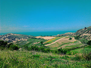
 Overlooking the hills in Bago | |
 Projected map of Kavajë District as defined by the Territorial-Administrative Reform of 2014 | |
| Country | |
| Prefecture(s) | Durrës, Tirana |
| Established | 1953-1958, 1991-2000 |
| Area | |
• District (2013 est.) | 414 km2 (160 sq mi) |
| Elevation | 51 m (167 ft) |
| Time zone | UTC+1 (CET) |
| • Summer (DST) | UTC+2 (CEST) |
| Postal code | 2500 |
| Area code | (0)55 |
| Vehicle registration | KJ |
The District of Kavajë (Template:Lang-sq) was one of the 36 Districts of Albania. Centrally located in the Western Lowlands region of the country, it had a total surface area of 414 km2 (160 sq mi) and consisted of 2 municipalities and 77 villages and localities. Its population in 2013 terms[1] was estimated at 117,152 inhabitants.[2][3]
Administrative Divisions
- Municipalities (2)
- Villages (65; *12 unincorporated)
- Agonas
- Bago
- Ballaj
- Beden
- Blerimaj
- Bukaq
- Çetë
- Cikallesh
- Damarkaj
- Domën
- Fliballie
- Gërmej
- Golem
- Golemas
- Gosë e Madhe
- Gosë e Vogël
- Habilaj
- Hajdaraj
- Harizaj
- Hasdushk
- Hemenraj
- Helmës
- Kalush
- Kanaparaj
- Karpen
- Kërçukaj
- Koçaj-Sheshaj
- Kryemdhenj
- Kryevidh
- Kryezi
- Lekaj
- Çollakaj
- Lis-Patros
- Luz i Madh
- Luz i Vogël
- Mamël
- Methasanaj
- Mlik
- Mushnikë
- Okshtun
- Patk-Milot
- Peqinaj
- Qerret
- Rostej
- Rrakull
- Rreth-Greth
- Rrikaj
- Seferaj
- Sinaballaj
- Spanesh
- Spille
- Stan i Ri
- Stërbeg
- Synej
- Sharrdushk
- Shkozet
- Shtodhër
- Tilaj
- Thartor
- Vilë-Ballaj
- Vorrozen
- Zanbishë
- Zikularaj
- Zikxhafaj
- Zhabjak
