Montfoort: Difference between revisions
Appearance
Content deleted Content added
No edit summary |
|||
| Line 1: | Line 1: | ||
{{distinguish|Montfort}} |
{{distinguish|Montfort (disambiguation)}} |
||
{{Infobox settlement |
{{Infobox settlement |
||
<!-- See Template:Infobox settlement for additional fields and descriptions --> |
<!-- See Template:Infobox settlement for additional fields and descriptions --> |
||
Revision as of 02:31, 26 December 2014
Montfoort | |
|---|---|
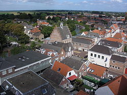
 Montfoort city centre | |
 Location in Utrecht | |
| Country | Netherlands |
| Province | Utrecht |
| Government | |
| • Body | Municipal council |
| • Mayor | Bert Jansen (D66) |
| Area | |
• Total | 38.20 km2 (14.75 sq mi) |
| • Land | 37.57 km2 (14.51 sq mi) |
| • Water | 0.63 km2 (0.24 sq mi) |
| Elevation | 2 m (7 ft) |
| Population (January 2021)[4] | |
• Total | 13,896 |
| • Density | 370/km2 (1,000/sq mi) |
| Time zone | UTC+1 (CET) |
| • Summer (DST) | UTC+2 (CEST) |
| Postcode | 3417, 3460–3461 |
| Area code | 0348 |
| Website | www |
Montfoort (Dutch pronunciation: [ˈmɔntfoːrt] ) is a municipality and a town in the Netherlands, in the province of Utrecht. Montfoort received city rights in 1329.
Population centres
The municipality of Montfoort consists of the following cities, towns, villages and/or districts: Montfoort, Linschoten, Willeskop.

References
- ^ "burgemeester E.L. (Bert) Jansen" (in Dutch). Gemeente Montfoort. Retrieved 7 April 2014.
{{cite web}}: Unknown parameter|trans_title=ignored (|trans-title=suggested) (help) - ^ "Kerncijfers wijken en buurten 2020" [Key figures for neighbourhoods 2020]. StatLine (in Dutch). CBS. 24 July 2020. Retrieved 19 September 2020.
- ^ "Postcodetool for 3417JG". Actueel Hoogtebestand Nederland (in Dutch). Het Waterschapshuis. Retrieved 7 April 2014.
{{cite web}}: Cite has empty unknown parameter:|trans_title=(help) - ^ "Bevolkingsontwikkeling; regio per maand" [Population growth; regions per month]. CBS Statline (in Dutch). CBS. 1 January 2021. Retrieved 2 January 2022.
External links
 Media related to Montfoort at Wikimedia Commons
- Official website


