Chungara–Tambo Quemado: Difference between revisions
Appearance
Content deleted Content added
Per WP:INFOBOXFLAG |
|||
| Line 26: | Line 26: | ||
[[Category:Bolivia–Chile border crossings]] |
[[Category:Bolivia–Chile border crossings]] |
||
[[Category:Geography of Arica y Parinacota Region]] |
[[Category:Geography of Arica y Parinacota Region]] |
||
[[Category: |
[[Category:Landforms of Oruro Department]] |
||
Revision as of 22:46, 15 February 2015
| Chungara–Tambo Quemado | |
|---|---|
 | |
| Elevation | ~4600 m |
| Location | Bolivia–Chile border |
| Range | Andes |
| Coordinates | 18°17′05″S 69°04′17″W / 18.28472°S 69.07139°W |
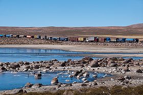
Chungara–Tambo Quemado (Template:Lang-es) is a mountain pass through the Cordillera Occidental of the Andes along the border between Chile and Bolivia. Chungara–Tambo Quemado is one of the principal Chile-Bolivia passes in the central Andes as it connects La Paz with its nearest seaport Arica.
