Nevelskoy Strait: Difference between revisions
Appearance
Content deleted Content added
m copyedit, already indirectly in category, refine cat, and AWB general fixes using AWB |
refine category structure |
||
| Line 8: | Line 8: | ||
The strait was a place for the contemplated [[Sakhalin Tunnel]]. |
The strait was a place for the contemplated [[Sakhalin Tunnel]]. |
||
[[Category:Straits of |
[[Category:Straits of Sakhalin Oblast]] |
||
[[Category:Straits of Asia]] |
|||
[[Category:Straits of Russia]] |
|||
[[Category:Landforms of Sakhalin Oblast]] |
|||
Revision as of 00:45, 2 March 2015
52°10′13″N 141°36′19″E / 52.17028°N 141.60528°E


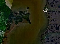
The Nevelskoy Strait (Template:Lang-ru) is a strait between Eurasia and Sakhalin that connects the main body of the Strait of Tartary with the Amur Liman (Amur River estuary). It was named in memory of Capt. Gennady Nevelskoy who in 1849 definitively established that the Strait of Tartary is connected with the Amur estuary and thus is in fact a strait, and not a gulf.
Length: 56 km, width (narrowest): 7.3 km, fairway depth: 7.2 m.
The strait was a place for the contemplated Sakhalin Tunnel.
