Meesdorf: Difference between revisions
added Category:Melle, Germany; removed {{uncategorized}} using HotCat |
added Category:Osnabrück (district) using HotCat |
||
| Line 46: | Line 46: | ||
[[Category:Germany]] |
[[Category:Germany]] |
||
[[Category:Melle, Germany]] |
[[Category:Melle, Germany]] |
||
[[Category:Osnabrück (district)]] |
|||
Revision as of 15:35, 31 July 2015
This article has multiple issues. Please help improve it or discuss these issues on the talk page. (Learn how and when to remove these messages)
|

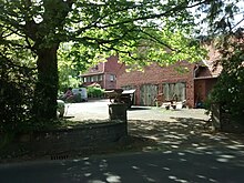
Meesdorf (Germany) is a part of the municipality of Buer in the city of Melle in Osnabrück, Lower Saxony. It lies in the Wiehen hills in Hunte valley. It was originally named "Metdisdorphe".[1]
Tourism

In the northern parts of Hunte Valley, dinosaur tracks were discovered. The erected building is Rainsave, also from Barkhausen are many signs to that never closed exhibition. At Hunte Valley, explorers find many ways that lead into the Wiehenhills. The "Rote Pfahl" is a marker at the side of the road, where the trader's route through Meesdorf in the 19th century is recorded. To get over the Bad Essen hill, the traders from Bremen had to use additional horses for their wagons. The marker was used as a signal on the road, for the traders that rested their roadtrain. Of course it also represented a rallypoint in case something dangerous ever happens(crimes, accidents etc.).[2]
The 13 ton boulder flint at the Glockenstraße crossroads reminds visitors of the village's deep history.[3]
Clubs
- Oldtimer-Machines Melle-Buer [4]
- Homelandclub, inside the Oldtimermuseum
- Soccersports Meesdorf[5]
- Rabbitbreeding Buer [6]
Festivals

- Sportsfestival at soccersplace
- Easter Fire at tentsplace
- Hunters Meeting with venisonmeal
- Saint Nicholas Festival
Economy
The land is mostly used for conventional farming. Roads are used for sports like Nordic walking. The local camping ground can host about 200 people. Other uses include:
- timber and woodworking industry
- metal manufacturing
- farm machine dealer
- cargo company
- junkyard
- information engineering
Famous people
- Ernst Buermeyer (1883–1945), educator, mayor of Gildehaus (Bad Bentheim) Gildehaus, party member of (DVP) and (NSDAP)
Notes
52°15′49″N 8°24′37″E / 52.2636°N 8.4104°E
This article needs additional or more specific categories. (July 2015) |
