Devils Hole: Difference between revisions
No edit summary |
No edit summary |
||
| Line 12: | Line 12: | ||
Devils Hole is the only natural habitat of the [[Devils Hole pupfish]], which thrives despite the hot, oxygen-poor water. It is an [[IUCN Red List]] [[endangered species]]. The enclosing cave is occasionally used as a roost for [[barn owl]]s, which tend to increase [[diatom]] growth via [[guano]]. |
Devils Hole is the only natural habitat of the [[Devils Hole pupfish]], which thrives despite the hot, oxygen-poor water. It is an [[IUCN Red List]] [[endangered species]]. The enclosing cave is occasionally used as a roost for [[barn owl]]s, which tend to increase [[diatom]] growth via [[guano]]. |
||
==Ash Meadows== |
|||
Ash Meadows is the discharge point for a groundwater system extending over a hundred miles to the northeast. Thirty seeps and springs bring to the surface "fossil" water which entered the groundwater system thousands of years ago. Ash Meadows is home to 26 species of endemic plants and animals, including three other endangered fish (two of them pupfish) and seven threatened plants. |
|||
==See also== |
==See also== |
||
Revision as of 22:57, 10 September 2015


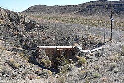
Devils Hole is a geologic formation located within the Ash Meadows National Wildlife Refuge, in Nye County, Nevada Southwestern United States.
Devils Hole--a detached unit of Death Valley National Park--is habitat for the only naturally occurring population of the endangered Devils Hole pupfish (Cyprinodon diabolis). The 40 acre (16 ha) unit is a part of the Ash Meadows complex, an area of desert uplands and spring-fed oasis designated a national wildlife refuge in 1984.
Description
Devils Hole is a geothermal pool within a limestone cavern in the Amargosa Desert in the Amargosa Valley of Nevada, east over the Amargosa Range and Funeral Mountains from Death Valley. Its waters are a near constant salinity and temperature (92 °F or 33 °C).[1]
Devils Hole branches into deep caverns at least 300 feet (91 m) deep from an opening at the surface that is approximately 6 by 18 feet (1.8 by 5.5 m). According to geologists, the caves were formed over 500,000 years ago.[2] The pool has frequently experienced activity due to far away earthquakes,[1] which have been likened to extremely small scale tsunamis.
Devils Hole is the only natural habitat of the Devils Hole pupfish, which thrives despite the hot, oxygen-poor water. It is an IUCN Red List endangered species. The enclosing cave is occasionally used as a roost for barn owls, which tend to increase diatom growth via guano.
Ash Meadows
Ash Meadows is the discharge point for a groundwater system extending over a hundred miles to the northeast. Thirty seeps and springs bring to the surface "fossil" water which entered the groundwater system thousands of years ago. Ash Meadows is home to 26 species of endemic plants and animals, including three other endangered fish (two of them pupfish) and seven threatened plants.
See also
References
- ^ a b Devils Hole. National Park Service http://www.nps.gov/deva/naturescience/devils-hole.htm. Retrieved 28 January 2014.
{{cite web}}: Missing or empty|title=(help) - ^ Landwehr, J. M.; I. J. Winograd (2012-03-01). Devils Hole, Nevada - A Primer : U.S. Geological Survey Fact Sheet 2012-3021 (PDF). U.S. Geological Survey. Retrieved 2013-01-17.
- Landwehr, J.M. and Winograd, I.J., 2012, Devils Hole, Nevada—A Primer: U.S. Geological Survey Fact Sheet 2012–3021, 6 p., available online at http://pubs.usgs.gov/fs/2012/3021.
External links
- "Devils Hole". Geographic Names Information System. United States Geological Survey, United States Department of the Interior. Retrieved 2009-08-10.
- The Southwestern Naturalist: "Pupfish Populations"
Devils Hole.
