Bhedetar: Difference between revisions
Appearance
Content deleted Content added
m cleanup (wikitables, html markup, layout, etc.) |
No edit summary |
||
| Line 42: | Line 42: | ||
| area_total_km2 = <!-- ALL fields dealing with a measurements are subject to automatic unit conversion--> |
| area_total_km2 = <!-- ALL fields dealing with a measurements are subject to automatic unit conversion--> |
||
| elevation_footnotes = |
| elevation_footnotes = |
||
| elevation_m = |
| elevation_m = 1420 |
||
| elevation_ft = |
| elevation_ft = |
||
<!-- Population --> |
<!-- Population --> |
||
Revision as of 08:43, 11 September 2015
Vedatar
भेडेटार | |
|---|---|
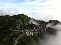
 Vedatar area as viewed from hight. | |
| Country | |
| Zone | Kosi Zone |
| District | Dhankuta District |
| Elevation | 1,420 m (4,660 ft) |
| Population (2011) | |
• Total | 2,977 |
| Time zone | UTC+5:45 (Nepal Time) |
| Postal code | 56804 |
| Area code | 026 |
| Nearest city | Dharan |
Vedatar is a village development committee in Dhankuta District in the Kosi Zone of eastern Nepal. At the time of the 1991 Nepal census it had a population of 2643 people living in 513 individual households.[1]
References
- ^ "Nepal Census 2001". Nepal's Village Development Committees. Digital Himalaya. Retrieved 24 November 2008.

