Hatterrall Ridge: Difference between revisions
| Line 10: | Line 10: | ||
==Geology== |
==Geology== |
||
The hill is composed |
The hill is composed of [[sandstone]]s and [[mudstone]]s of the Senni Formation of the [[Old Red Sandstone]] which is of [[Devonian]] age. Numerous small quarries adorn its slopes, though all are now abandoned. The shape of the [[Vale of Ewyas]] to the south and west of the ridge strongly suggests that it was occupied by a glacier during at least [[Quaternary glaciation|one ice age]], though not perhaps during the [[Last glacial period|last ice age]].<ref>Humpage, J.A. and Thomas, G.S.P. in Carr, S.J. et al (eds) ''Quaternary of the Brecon Beacons: a field guide'' 2007 Quaternary Research Association p184</ref> The plateau was probably ice-free. |
||
The ridge is often used for paragliding and hang gliding when the wind is from the east or east-north-east. |
The ridge is often used for [[paragliding]] and [[hang gliding]] when the wind is from the east or east-north-east. |
||
== References == |
== References == |
||
Revision as of 16:54, 20 September 2015

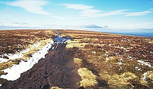
The Hatterrall Ridge (sometimes spelled Hatterall) is a ridge in the Black Mountains forming the border between Powys and Monmouthshire in Wales and Herefordshire in England. The ridge is about 10 miles (16 km) long, and is followed by the Offa's Dyke Path. On the west side of the ridge is the Vale of Ewyas, and on the east side is the river Olchon Valley. The western side of the ridge falls within the Brecon Beacons National Park. Much of the northern part of the ridge is a broad whaleback, but it narrows down considerably further south, and especially near to Llanthony Priory in the Vale of Ewyas to the west of the mountain. There is a large and prominent landslip on the eastern side of the mountain here, known as Black Darren, where a large slice of the rocks has fallen away from the main mass of the hill.
The ridge to the southwest ends abruptly at the sheer cliff known as the Darren below which is a considerable landslipped area extending south to the hamlet of Cwmyoy with its mis-shapen church.
Peaks
The highest point on the ridge is Black Mountain (elevation 703 m), near its northern end. Hatterrall Hill (elevation 531 m) is near the southern end of the ridge. The path is very peaty and wet underfoot in most parts of the mountain. The ridge is common land grazed by sheep, ponies and cattle.[1]

Geology
The hill is composed of sandstones and mudstones of the Senni Formation of the Old Red Sandstone which is of Devonian age. Numerous small quarries adorn its slopes, though all are now abandoned. The shape of the Vale of Ewyas to the south and west of the ridge strongly suggests that it was occupied by a glacier during at least one ice age, though not perhaps during the last ice age.[2] The plateau was probably ice-free.
The ridge is often used for paragliding and hang gliding when the wind is from the east or east-north-east.
References
- ^ Brecon Beacons National Park website
- ^ Humpage, J.A. and Thomas, G.S.P. in Carr, S.J. et al (eds) Quaternary of the Brecon Beacons: a field guide 2007 Quaternary Research Association p184
