Valandovo Municipality: Difference between revisions
Appearance
Content deleted Content added
Sashko1999 (talk | contribs) No edit summary |
new key for Category:Valandovo: " " using HotCat |
||
| Line 47: | Line 47: | ||
[[Category:Municipalities of the Republic of Macedonia]] |
[[Category:Municipalities of the Republic of Macedonia]] |
||
[[Category:Valandovo]] |
[[Category:Valandovo| ]] |
||
Revision as of 00:28, 11 November 2015
Valandovo Municipality
Општина Валандово | |
|---|---|
Urban municipality | |
 | |
| Country | |
| Region | Southeastern Statistical Region |
| Municipal seat | Valandovo |
| Government | |
| • Mayor | Nikolche Churlinovski (VMRO-DPMNE) |
| Population | |
• Total | 11,890 |
| Time zone | UTC+1 (CET) |
| Website | http://www.valandovo.gov.mk/ |
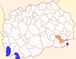
Valandovo (Template:Lang-mk [vaˈɫandɔvɔ] ⓘ) is a municipality in southern part of Republic of Macedonia. Valandovo is also the name of the town where the municipal seat is found. Valandovo Municipality is part of Southeastern Statistical Region.
Geography
The municipality borders Demir Kapija Municipality to the northwest, Konče Municipality to the north, Strumica Municipality to the northeast, Greece to the east, Dojran Municipality and Bogdanci Municipality to the south, and Gevgelija Municipality to the southwest.
Demographics
According to the last national census from 2002, this municipality has 11,890 inhabitants.[1] Ethnic groups in the municipality include:
- Macedonians = 9,830 (82.7%)
- Turks = 1,333 (11.2%)
- Serbs = 639 (5.4%)
- others.
References
- ^ 2002 census results in English and Macedonian (PDF)


