Takko: Difference between revisions
m Spelling Corrections, Updated Town Hall Zip Code |
m →Education: Added school names |
||
| Line 143: | Line 143: | ||
==Economy== |
==Economy== |
||
The economy of Takko is heavily dependent on agriculture and forestry. The main crop is [[garlic]], of which Takko is Japan's largest producer. |
The economy of Takko is heavily dependent on agriculture and forestry. The main crop is [[garlic]], of which Takko is Japan's largest producer. Other main crops include tobacco, rice and apples. |
||
==Education== |
==Education== |
||
Takko has three elementary schools, one middle school and one high school. |
Takko has three elementary schools, one middle school and one high school. |
||
'''High School (1)''' |
|||
* [http://www.takko-h.asn.ed.jp/ Takko Senior High School] (Prefectural) |
|||
'''Middle School (1)''' |
|||
* Takko Junior High School |
|||
'''Elementary Schools (3)''' |
|||
* Takko Elementary School |
|||
* Shimizugashira Elementary School |
|||
* Kamigō Elementary School |
|||
'''Kindergarden (1)''' |
|||
* Takko Kindergarten |
|||
'''Nursery Schools (2)''' |
|||
* Takko Hoikuen |
|||
* Kamigo Hoikuen |
|||
==Transportation== |
==Transportation== |
||
Revision as of 07:38, 8 April 2016
This article needs additional citations for verification. (November 2015) |
Takko
田子町 | |
|---|---|
Town | |
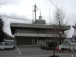
 Takko Town Hall | |
 Location of Takko in Aomori Prefecture | |
| Country | Japan |
| Region | Tōhoku |
| Prefecture | Aomori Prefecture |
| District | Sannohe |
| Area | |
• Total | 241.98 km2 (93.43 sq mi) |
| Population (September 1 2015) | |
• Total | 5,462 |
| • Density | 22.6/km2 (59/sq mi) |
| Time zone | UTC+9 (Japan Standard Time) |
| - Tree | Japanese Rowan |
| - Flower | Rhododendron |
| - Bird | wagtail |
| Phone number | 0179-32-3111 |
| Address | 81 Tenjindōtai Takko-machi, Sannohe-gun, Aomori-ken 039-0292 |
| Website | Official website |
Takko (田子町, Takko-machi) is a town located in Sannohe District of southeastern Aomori Prefecture in the northern Tōhoku region of Japan. As of September 2015, the town had an estimated population of 5,463 and a population density of 23.6 persons per km². Its total area was 241.98 square kilometres (93.43 sq mi).
Geography
Takko occupies the far southeast corner of Aomori Prefecture, south of the Hakkoda Mountains. Much of the town is mountainous, and has a cold maritime climate characterized by cool, short summers and long, cold winters with extremely heavy snowfall. The mountainous area is home to many indigenous plant and animal species. Wildlife includes Japanese Macaque monkeys, kamoshika, tanuki, and Asian black bears.
Neighbouring municipalities
History
The area around Takko has been inhabited since prehistoric times, and numerous Jomon period remains have been discovered. The town name is derived from an Ainu word “tapkop”, meaning “small hill”. During the Edo period, the area was controlled by the Nambu clan of Morioka Domain and later by Hachinohe Domain. During the cadastral reform of 1889, Takko Village was created as a separate village from former Kamigō Village. It was elevated to town status on November 10, 1928. On March 1, 1955, Kamigō Village merged back with Takko Town.
Economy
The economy of Takko is heavily dependent on agriculture and forestry. The main crop is garlic, of which Takko is Japan's largest producer. Other main crops include tobacco, rice and apples.
Education
Takko has three elementary schools, one middle school and one high school.
High School (1)
- Takko Senior High School (Prefectural)
Middle School (1)
- Takko Junior High School
Elementary Schools (3)
- Takko Elementary School
- Shimizugashira Elementary School
- Kamigō Elementary School
Kindergarden (1)
- Takko Kindergarten
Nursery Schools (2)
- Takko Hoikuen
- Kamigo Hoikuen
Transportation
Highway
Noted people from Takko
- Sampachi Kawa – manga artist
Sister city relations
 – Gilroy, California, USA since April 18, 1988[1]
 – Monticelli d'Ongina, Emilia-Romagna, Italy [2] – since September 11, 1992
 - Seosan, South Chungcheong Province, Korea since June 22, 2012 [1]
References
- ^ a b "Takko, Aomori official home page" (PDF). 姉妹都市との交流 (in Japanese). 2015. Retrieved 22 November 2015.
- ^ "Commune Monticelli d'Ongina official home page" (in Italian). Retrieved 20 November 2015.


