Ait Irane: Difference between revisions
No edit summary |
No edit summary |
||
| Line 49: | Line 49: | ||
| elevation_ft = |
| elevation_ft = |
||
| population_total = 1173 |
| population_total = 1173 |
||
| population_as_of = 2010<ref>[http://www.tiziouzou-dz.com/population-evolu-intercensit.htm Evolution intercensitaire de la population sur le site de la wilaya de Tizi Ouzou]. |
| population_as_of = 2010<ref>[http://www.tiziouzou-dz.com/population-evolu-intercensit.htm Evolution intercensitaire de la population sur le site de la wilaya de Tizi Ouzou]. Consult 02/25/2011</ref> |
||
| population_footnotes = |
| population_footnotes = |
||
| population_density_km2 = |
| population_density_km2 = |
||
| Line 62: | Line 62: | ||
| blank_name = |
| blank_name = |
||
| blank_info = |
| blank_info = |
||
}}'''Aït Irane''' ([[Taqbaylit language|Taqbaylit]]: {{IPA- |
}}'''Aït Irane''' ([[Taqbaylit language|Taqbaylit]]: {{IPA-fr|ath yir'en||AitIrane.ogg}}), ath yirane (in kabyle) ⴰⵉⵜ ⵉⵔⴰⵏⴻ in Tifinagh, means '''izmawen''' , is a village of Kabylie, which belongs to the commune [[Aït Bouadou|Ait Bouaddou]] , |
||
'''Aït Bouaddou,''' also called Ath Vouvaddou or Beni Bouaddou, is a commune of the [[Ouadhia District]] (Daïra) which is a [[Tizi Ouzou Province]] (Wilaya) in the [[Kabylie]] region of [[Algeria]]. |
'''Aït Bouaddou,''' also called Ath Vouvaddou or Beni Bouaddou, is a commune of the [[Ouadhia District]] (Daïra) which is a [[Tizi Ouzou Province]] (Wilaya) in the [[Kabylie]] region of [[Algeria]]. |
||
| Line 84: | Line 84: | ||
The |
The |
||
ranfalls variations between the moister month and the dryer month is 145 mm. |
ranfalls variations between the moister month and the dryer month is 145 mm. |
||
Yearly Temperature Variation is 19.2°C<ref> |
Yearly Temperature Variation is 19.2°C<ref>[http://fr.climate-data.org/location/693594/ Climat: Ait Irane]] consultation 04/13/2016}}</ref>. |
||
=== Géolocalisation === |
=== Géolocalisation === |
||
Revision as of 02:21, 4 May 2016
This article needs additional citations for verification. (May 2016) |
Aït Irane
ⴰⵉⵜ ⵉⵔⴰⵏⴻ آيت إيران | |
|---|---|
Village | |
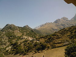
 View of the Djurdjura Range | |
| Nickname: Ath Yiran or At Yiran | |
 | |
| Country | |
| Province | Tizi Ouzou |
| District | Ouadhia |
| Communes | Aït Bouaddou |
| Elevation | 2,766 ft (843 m) |
| Population (2010[1]) | |
• Total | 1,173 |
| Time zone | UTC+1 (CET) |
Aït Irane (Taqbaylit: [ath yir'en] Audio file "AitIrane.ogg" not found), ath yirane (in kabyle) ⴰⵉⵜ ⵉⵔⴰⵏⴻ in Tifinagh, means izmawen , is a village of Kabylie, which belongs to the commune Ait Bouaddou ,
Aït Bouaddou, also called Ath Vouvaddou or Beni Bouaddou, is a commune of the Ouadhia District (Daïra) which is a Tizi Ouzou Province (Wilaya) in the Kabylie region of Algeria.
Géography
Superficy to determine (in the information frame of the page)
Climat
The village Ait Irane benefits a hot temperated climate.
Ait Irane have a average year temperature is 15.4°C. Hottest Month of the year is august with an average temperature 26.2°C. In January, the average temperature is 7.0°C. Every year, rainfalls are in the average of 921 mm.
The lessest average rainfalls are in July with only 4 mm. In January, rainfalls are the most important, with an average of 149 mm.
The ranfalls variations between the moister month and the dryer month is 145 mm. Yearly Temperature Variation is 19.2°C[2].
Géolocalisation
Aït Bouaddou Villages
Aït Bouaddou is composed by nine villages:[3]
- Aït Amar
- Aït Djemaa, Commune Head-quarter
- Aït Khalfa
- Ait Irane, at the altitude of 813 meters.
- Aït Ouel Hadj
- Aït Maalem
- Ibadissen
- Takherradjit
- Tamkarbout
History
French Invasion
Algeria war
Since Independence Day (5 July 1956)
From 2013 to nowadays
Personnalities
This section is empty. You can help by adding to it. (May 2016) |
Notes and references
- ^ Evolution intercensitaire de la population sur le site de la wilaya de Tizi Ouzou. Consult 02/25/2011
- ^ Climat: Ait Irane] consultation 04/13/2016}}
- ^ Journal officiel de la République Algérienne, 19 décembre 1984.


