Market Street Power Plant: Difference between revisions
Appearance
Content deleted Content added
Short Video |
|||
| Line 4: | Line 4: | ||
{{Commonscat|NOPSI Power Plant, South Peters Street, New Orleans}} |
{{Commonscat|NOPSI Power Plant, South Peters Street, New Orleans}} |
||
{{Coord|29|55|48|N|90|3|51|W|dim:500_region:US-LA_type:landmark|display=title}} |
{{Coord|29|55|48|N|90|3|51|W|dim:500_region:US-LA_type:landmark|display=title}}[https://www.youtube.com/watch?v=siIyUjm1ihQ&feature=youtu.be] |
||
[[Category:Buildings and structures in New Orleans, Louisiana]] |
[[Category:Buildings and structures in New Orleans, Louisiana]] |
||
Revision as of 02:24, 28 May 2016

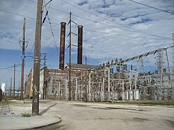
The Market Street Power Plant is a defunct early 20th Century power plant in New Orleans, Louisiana. It is located along the Mississippi River just upriver of the Crescent City Connection and Ernest N. Morial Convention Center. The plant was constructed in 1905 and shut down in 1973. In early 2007, Entergy New Orleans sold the plant and surrounding property to Market Street Properties LLC for $10 million. Current plans are to redevelop the plant for public use, which may correspond with elements of the Riverfront Vision 2005 Plan. Residential development is planned for the surrounding area.
Wikimedia Commons has media related to NOPSI Power Plant, South Peters Street, New Orleans.
