Montfoort: Difference between revisions
Appearance
Content deleted Content added
mNo edit summary |
|||
| Line 87: | Line 87: | ||
'''Montfoort''' ({{IPA-nl|ˈmɔntfoːrt|-|Nl-Montfoort.ogg}}) is a municipality and a city in the [[Netherlands]], in the province of [[Utrecht (province)|Utrecht]]. Montfoort received [[City rights in the Netherlands|city rights]] in 1329. |
'''Montfoort''' ({{IPA-nl|ˈmɔntfoːrt|-|Nl-Montfoort.ogg}}) is a municipality and a city in the [[Netherlands]], in the province of [[Utrecht (province)|Utrecht]]. Montfoort received [[City rights in the Netherlands|city rights]] in 1329. |
||
==Montfoort is een beetje saaaii == |
|||
==Population centres == |
|||
The municipality of Montfoort consists of the following cities, towns, villages and/or districts: [[Achthoven (Montfoort)|Achthoven-West]], Achthoven-Oost, [[Blokland (Montfoort)|Blokland]], [[Cattenbroek]], [[Knollemanshoek]], [[Linschoten (village)|Linschoten]], [[Mastwijk]], Montfoort, [[Willeskop]]. |
The municipality of Montfoort consists of the following cities, towns, villages and/or districts: [[Achthoven (Montfoort)|Achthoven-West]], Achthoven-Oost, [[Blokland (Montfoort)|Blokland]], [[Cattenbroek]], [[Knollemanshoek]], [[Linschoten (village)|Linschoten]], [[Mastwijk]], Montfoort, [[Willeskop]]. |
||
Revision as of 07:30, 17 June 2016
Montfoort | |
|---|---|
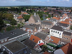
 Montfoort city centre | |
 Location in Utrecht | |
| Country | Netherlands |
| Province | Utrecht |
| Government | |
| • Body | Municipal council |
| • Mayor | Petra van Hartskamp (VVD) |
| Area | |
• Total | 38.20 km2 (14.75 sq mi) |
| • Land | 37.57 km2 (14.51 sq mi) |
| • Water | 0.63 km2 (0.24 sq mi) |
| Elevation | 2 m (7 ft) |
| Population (January 2021)[4] | |
• Total | 13,896 |
| • Density | 370/km2 (1,000/sq mi) |
| Time zone | UTC+1 (CET) |
| • Summer (DST) | UTC+2 (CEST) |
| Postcode | 3417, 3460–3461 |
| Area code | 0348 |
| Website | www |
Montfoort (Template:IPA-nl) is a municipality and a city in the Netherlands, in the province of Utrecht. Montfoort received city rights in 1329.
Montfoort is een beetje saaaii
The municipality of Montfoort consists of the following cities, towns, villages and/or districts: Achthoven-West, Achthoven-Oost, Blokland, Cattenbroek, Knollemanshoek, Linschoten, Mastwijk, Montfoort, Willeskop.
Topography
Dutch topographic map of the municipality of Montfoort, June 2015

References
- ^ "burgemeester E.L. (Bert) Jansen" (in Dutch). Gemeente Montfoort. Retrieved 7 April 2014.
{{cite web}}: Unknown parameter|trans_title=ignored (|trans-title=suggested) (help) - ^ "Kerncijfers wijken en buurten 2020" [Key figures for neighbourhoods 2020]. StatLine (in Dutch). CBS. 24 July 2020. Retrieved 19 September 2020.
- ^ "Postcodetool for 3417JG". Actueel Hoogtebestand Nederland (in Dutch). Het Waterschapshuis. Retrieved 7 April 2014.
{{cite web}}: Cite has empty unknown parameter:|trans_title=(help) - ^ "Bevolkingsontwikkeling; regio per maand" [Population growth; regions per month]. CBS Statline (in Dutch). CBS. 1 January 2021. Retrieved 2 January 2022.
External links
 Media related to Montfoort at Wikimedia Commons
- Official website


