Sathyagala: Difference between revisions
Appearance
Content deleted Content added
Added one picture |
inserted four pictures |
||
| Line 69: | Line 69: | ||
* [[Districts of Karnataka]] |
* [[Districts of Karnataka]] |
||
==Image Gallery== |
|||
<gallery> |
|||
File:School at Sathyagala.jpg|Sathyagala School |
|||
File:Sathyagala. Gool rashan zameer.jpg|Dargah Gool rashan zameer |
|||
File:Dargah on Shivanasamudra road.jpg|Dargah near school |
|||
File:Tree worship at Sathyakala Handpost.jpg|Temple near school |
|||
</gallery> |
|||
==References== |
==References== |
||
{{reflist}} |
{{reflist}} |
||
Revision as of 11:28, 12 August 2016
Sathyagala | |
|---|---|
village | |
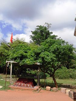
 Dargah at Sathyagala | |
 | |
| Country | |
| State | Karnataka |
| District | Chamarajanagar |
| Talukas | Kollegal |
| Population (2001) | |
• Total | 12,503 |
| Languages | |
| • Official | Kannada |
| Time zone | UTC+5:30 (IST) |
Sathegala is a village in the southern state of Karnataka, India.[1][2] It is located in the Kollegal taluk of Chamarajanagar district in Karnataka.
Demographics
As of the 2001 India census, Sathegala had a population of 12503, with 6518 males and 5985 females.[1]
See also
Image Gallery
-
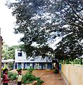
Sathyagala School
-
Dargah Gool rashan zameer
-
Dargah near school
-
Temple near school
References
- ^ a b Village code= 2926900 "Census of India : Villages with population 5000 & above". Retrieved 2008-12-18.
{{cite web}}:|first=missing|last=(help)CS1 maint: multiple names: authors list (link) - ^ "Yahoomaps India :". Retrieved 2008-12-18. Sathegala, Chamarajanagar, Karnataka
External links


