Bhedetar: Difference between revisions
Appearance
Content deleted Content added
No edit summary |
m typo |
||
| Line 8: | Line 8: | ||
<!-- images and maps --> |
<!-- images and maps --> |
||
| image_skyline = भेडेटार, धरान.JPG |
| image_skyline = भेडेटार, धरान.JPG |
||
| image_caption = Bhedetar |
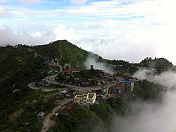
| image_caption = Bhedetar aerial view |
||
| image_flag = |
| image_flag = |
||
| image_seal = |
| image_seal = |
||
Revision as of 07:15, 14 August 2016
Bhedetar
भेडेटार | |
|---|---|
 Bhedetar aerial view | |
| Country | |
| Zone | Kosi Zone |
| District | Dhankuta District |
| Elevation | 1,420 m (4,660 ft) |
| Population (2011) | |
• Total | 2,977 |
| Time zone | UTC+5:45 (NST) |
| Postal code | 56804 |
| Area code | 026 |
| Nearest city | Dharan |
Bhedetar is a village development committee in Dhankuta District in the Kosi Zone of eastern Nepal. At the time of the 1991 Nepal census it had a population of 2643 people living in 513 individual households.[1]
References
- ^ "Nepal Census 2001". Nepal's Village Development Committees. Digital Himalaya. Retrieved 24 November 2008.

