Délı̨nę: Difference between revisions
Mindmatrix (talk | contribs) stub sorting -> {{NorthwestTerritories-geo-stub}} |
added coordinates |
||
| Line 23: | Line 23: | ||
[[de:Déline]] |
[[de:Déline]] |
||
[[fr:Délįne]] |
[[fr:Délįne]] |
||
{{coor title dm|65|10|N|123|25|W|}} |
|||
Revision as of 21:08, 2 September 2006

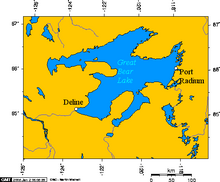
Délįne ("bear river") (formerly known as Fort Franklin until 1 June, 1993) is a community on the western shore of Great Bear Lake, in the Northwest Territories, Canada. It is located at 65°10′N 123°25′W / 65.167°N 123.417°W, 544 km northwest of Yellowknife.
Délįne (pronounced "DE-le-nay") has a population of 536 people (2001 Census), mainly Sahtu Dene people speaking North Slavey. Deline means "where the waters flow", a reference to the headwaters of the Great Bear River, Sahtu De.
The area became prominent when pitchblende was discovered at the Eldorado Mine, some 250 km away, on the eastern shore, at Port Radium. During World War II, the Canadian government took over the mine and began to produce uranium for the then-secret American nuclear bomb project. The village, became a permanent settlement in 1952, with the building of a school.
The Dene from Délįne, who were conscripted as ore carriers, were not informed about the risks of radioactivity or how to protect themselves. Most of those men who participated began to die of cancer in the 1960s.
According to oral history, while canoeing on Great Bear Lake in the early part of the 20th century, a Délįne elder reached a precipice where he had a vision of a great city burning, of people who comported First Nations features enduring great suffering. According to tradition, this precipice is where uranium was later discovered.
External links
Sources
- John Price, "Our own atomic victims," Victoria Times-Colonist
