Vélingara department: Difference between revisions
Appearance
Content deleted Content added
fix citation |
not a reliable ref using AWB (12082) |
||
| Line 81: | Line 81: | ||
|website = |
|website = |
||
|footnotes = |
|footnotes = |
||
}} |
}} |
||
'''Vélingara Department''' is one of the 45 [[departments of Senegal]], one of the three making up the [[Kolda Region]]. |
'''Vélingara Department''' is one of the 45 [[departments of Senegal]], one of the three making up the [[Kolda Region]]. |
||
| Line 93: | Line 93: | ||
** Médina Gounass |
** Médina Gounass |
||
** Sinthiang Koundara |
** Sinthiang Koundara |
||
* Arrondissement of Pakour |
* Arrondissement of Pakour |
||
** Pakour |
** Pakour |
||
** Paroumba |
** Paroumba |
||
** Ouassadou |
** Ouassadou |
||
*Arrondissement of Saré Coly Sallé |
*Arrondissement of Saré Coly Sallé |
||
** Saré Coly Sallé |
** Saré Coly Sallé |
||
| Line 105: | Line 103: | ||
** Némataba |
** Némataba |
||
==Historical site== |
|||
===Historical site<ref>List of historic sites [http://archive.wikiwix.com/cache/?url=http%3A%2F%2Fwww.culture.gouv.sn%2Farticle.php3%3Fid_article%3D3]</ref>=== |
|||
* Village of Payoungou, arrondissement of Pakour |
* Village of Payoungou, arrondissement of Pakour |
||
| Line 118: | Line 116: | ||
[[Category:Departments of Senegal]] |
[[Category:Departments of Senegal]] |
||
[[Category:Kolda Region]] |
[[Category:Kolda Region]] |
||
{{Senegal-geo-stub}} |
{{Senegal-geo-stub}} |
||
Revision as of 22:36, 16 November 2016
Vélingara | |
|---|---|
 Location in the Kolda Region | |
| Country | |
| Region | Kolda Region |
| Capital | Vélingara |
| Area | |
• Total | 5,434 km2 (2,098 sq mi) |
| Population (2013 census) | |
• Total | 278,382 |
| • Density | 51/km2 (130/sq mi) |
| Time zone | UTC+0 (GMT) |
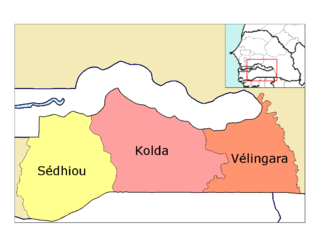
Vélingara Department is one of the 45 departments of Senegal, one of the three making up the Kolda Region.
The department has three communes: Vélingara, Kounkané and Diaobé-Kabendou.
The rural districts (Communautés rurales) comprise:
- Arrondissement of Bonkonto:
- Bonkonto
- Linkéring
- Médina Gounass
- Sinthiang Koundara
- Arrondissement of Pakour
- Pakour
- Paroumba
- Ouassadou
- Arrondissement of Saré Coly Sallé
- Saré Coly Sallé
- Kandia
- Kandiaye
- Némataba
Historical site
- Village of Payoungou, arrondissement of Pakour
References
13°9′00″N 14°7′00″W / 13.15000°N 14.11667°W
