Manitoulin District: Difference between revisions
municipalities |
m →Communities: Little Current |
||
| Line 25: | Line 25: | ||
* [[Cook's Dock, Ontario]] |
* [[Cook's Dock, Ontario]] |
||
* [[Fernlee, Ontario]] |
* [[Fernlee, Ontario]] |
||
* [[Little Current, Ontario]] |
|||
* [[M'Chigeeng First Nation, Ontario]] |
* [[M'Chigeeng First Nation, Ontario]] |
||
* [[Meldrum Bay, Ontario]] |
* [[Meldrum Bay, Ontario]] |
||
Revision as of 22:36, 18 October 2004
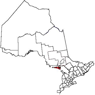
The Manitoulin District is a geographic and political subdivision in Ontario, Canada.
A district in Ontario is a division which is similar to a county, but which does not have its own level of government. Districts are found in Northern Ontario, which is much more sparsely populated than the southern portion of the province, and hence districts do not have the population base to provide county-level services (roads, etc.) on their own. In a district, these services are provided directly by the provincial government.
The Manitoulin District comprises Manitoulin Island and a number of small islands around it. Although it previously included the municipality of Killarney, Ontario on the mainland as well, Killarney was transferred to the Sudbury District in the late 1990s.
In 2001, the population of Manitoulin District was 12,679.
Municipalities
- Town of Gore Bay
- Town of Northeastern Manitoulin and The Islands
- Township of Assiginack
- Township of Barrie Island
- Municipality of Billings
- Township of Burpee and Mills
- Township of Central Manitoulin
- Township of Cockburn Island
- Township of Gordon
- Township of Tehkummah
Communities
- Cook's Dock, Ontario
- Fernlee, Ontario
- Little Current, Ontario
- M'Chigeeng First Nation, Ontario
- Meldrum Bay, Ontario
- Sheguiandah First Nation, Ontario
- Sheshegwaning First Nation, Ontario
- Silver Water, Ontario
- Sucker Creek First Nation, Ontario
- Tehkummah First Nation, Ontario
- Whitefish River First Nation, Ontario
- Wikwemikong First Nation, Ontario
- Zhiibaahaasing First Nation, Ontario
Provincial Highways
Manitoulin District is served by only one primary provincial highway, Highway 6. This highway enters the district at the ferry docks in South Baymouth, in the township of Tehkummah, where the Chi-Cheemaun ferry travels to and from Tobermory in the municipality of Northern Bruce Peninsula, Ontario. It exits the district in the Whitefish River First Nation, just south of Whitefish Falls, Ontario, when it crosses into the Sudbury District.
A number of secondary provincial highways, the equivalent in a district to a county or municipal road in Southern Ontario, serve the communities of Manitoulin Island. These are:
- Highway 540, which extends from the community of Little Current (Northeastern Manitoulin and the Islands) to Meldrum Bay, the westernmost settlement on the island,
- Highway 540A, which connects Barrie Island to Highway 540,
- Highway 540B, which connects Gore Bay to Highway 540,
- Highway 542, which extends from Highway 540 south of Gore Bay to Highway 6 near Tehkummah,
- Highway 542A, which connects the community of Tehkummah to Highway 542,
- Highway 551, which extends from M'Chigeeng (West Bay) to Providence Bay (Central Manitoulin).


