Kara-Suu District: Difference between revisions
Appearance
Content deleted Content added
pop+area |
|||
| Line 42: | Line 42: | ||
|established_date = |
|established_date = |
||
|area_magnitude = |
|area_magnitude = |
||
|unit_pref = |
|unit_pref = <!--Enter: Imperial, if Imperial (metric) is desired--> |
||
|area_footnotes = |
|area_footnotes = |
||
|area_total_km2 = |
|area_total_km2 = 3616 |
||
|area_land_km2 = |
|area_land_km2 = |
||
|area_water_km2 = |
|area_water_km2 = |
||
| Line 51: | Line 51: | ||
|area_water_sq_mi = |
|area_water_sq_mi = |
||
|area_water_percent = |
|area_water_percent = |
||
|area_urban_km2 = |
|||
|area_urban_sq_mi = |
|||
|area_metro_km2 = |
|||
|area_metro_sq_mi = |
|||
|population_as_of = 2009 |
|population_as_of = 2009 |
||
|population_footnotes = <ref name=stat/> |
|||
|population_footnotes = <ref name=stat>{{Citation | last = | first = | author-link = | last2 = | first2 = | author2-link = | title = Population and Housing Census 2009. Book 3 (in tables). Regions of Kyrgyzstan: Osh Region (Перепись населения и жилищного фонда Кыргызской Республики 2009. Книга 3 (в таблицах). Регионы Кыргызстана: Ошская область | place = Bishkek| publisher = National Committee on Statistics | origyear = | year =2010| month= | volume = | edition = | chapter = | chapterurl = | page = | pages = | url = http://212.42.101.100:8088/nacstat/sites/default/files/%D0%9E%D1%88%D1%81%D0%BA%D0%B0%D1%8F%20%D0%BE%D0%B1%D0%BB%D0%B0%D1%81%D1%82%D1%8C.pdf}}</ref> |
|||
|population_note = |
|population_note = |
||
|population_total = |
|population_total = 348645 |
||
|population_density_km2 = |
|population_density_km2 = auto |
||
|population_density_sq_mi = |
|population_density_sq_mi = |
||
|population_metro = |
|||
|population_density_metro_km2 = |
|||
|population_density_metro_sq_mi = |
|||
|population_urban = |
|||
|population_density_urban_km2 = |
|||
|population_density_urban_mi2 = |
|||
|timezone = GMT +5 |
|timezone = GMT +5 |
||
|utc_offset = +5 |
|utc_offset = +5 |
||
| Line 82: | Line 72: | ||
|footnotes = |
|footnotes = |
||
}} |
}} |
||
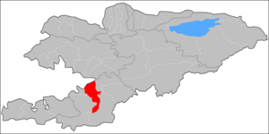
'''Kara-Suu ''' is a [[raion]] (district) of [[Osh Region]] in south-western [[Kyrgyzstan]]. The capital lies at [[Kara-Suu]]. |
'''Kara-Suu ''' is a [[raion]] (district) of [[Osh Region]] in south-western [[Kyrgyzstan]]. Its area is {{convert|3616|km2}}, and its resident population was 348,645 in 2009.<ref name=stat>{{Webarchive| title = 2009 population census of the Kyrgyz Republic: Osh Region | url = http://web.archive.org/web/20110810173811/http://212.42.101.100:8088/nacstat/sites/default/files/%D0%9E%D1%88%D1%81%D0%BA%D0%B0%D1%8F%20%D0%BE%D0%B1%D0%BB%D0%B0%D1%81%D1%82%D1%8C.pdf|archive-date= 10 August 2011}}</ref> The capital lies at [[Kara-Suu]].<ref>[http://enrin.grida.no/htmls/kyrghiz/soe2/english/map/map3.htm Enrin.grida.no]</ref> |
||
==Towns, rural communities, and villages== |
==Towns, rural communities, and villages== |
||
Revision as of 09:42, 26 January 2017
Kara-Suu | |
|---|---|
 | |
| Country | Kyrgyzstan |
| Region | Osh Region |
| Area | |
• Total | 3,616 km2 (1,396 sq mi) |
| Population (2009)[1] | |
• Total | 348,645 |
| • Density | 96/km2 (250/sq mi) |
| Time zone | UTC+5 (GMT +5) |
Kara-Suu is a raion (district) of Osh Region in south-western Kyrgyzstan. Its area is 3,616 square kilometres (1,396 sq mi), and its resident population was 348,645 in 2009.[1] The capital lies at Kara-Suu.[2]
Towns, rural communities, and villages
In total, Kara-Suu District include 1 town and 16 rural communities (aiyl okmotus). Each rural community can consist of one or several villages. The rural communities and settlements in the Kara-Suu District are:[3]
- town Kara-Suu
- Ak-Tash aiyl okmotu (center - village Ak-Tash, and also villages Jylkeldi, and Barak)
- Jangy-Aryk aiyl okmotu (center - village Jangy-Aryk, and also villages Ak-Terek, Pravda, Tas-Aryk, and Uch-Kun)
- Joosh aiyl okmotu (center - village Bol'shevik, and also villages Agartuu, Gayrat, Zarbalik, Imeni Kalinina, Kommunizm, Kyzyl-Koshchu, Kyzyl-Saray, Madaniyat, Mamajan, Pitomnik (former Progress), and Ak-Jar)
- Katta-Taldyk aiyl okmotu (center - village Bash-Bulak, and also villages Jany-Turmush, Kara-Seget, Taldyk, Kichik, Kyzyl-Ordo, Sadyrbay, Eshme, and Achy)
- Kashgar-Kyshtak aiyl okmotu (center - village Kashgar-Kyshtak, and also villages Alga-Bas, Andijan Mahalla, Bek-Jar, Jar-Ooz, Kenjegul, Tajik Mahalla, and Monok)
- Kyzyl-Kyshtak aiyl okmotu (center - village Kyzyl-Kyshtak, and also villages Andijanskoe, Bel-Kyshtak, Jangy-Kyshtak, Imeni Karla Marksa, Komminist, and Kyzyl Bayrak)
- Kyzyl-Suu aiyl okmotu (center - village Chaychi, and also villages Korgon, Alpordo, and Talaa)
- Mady aiyl okmotu (center - village Kyrgyz-Chek, and also villages Asanchek, Joosh, Kaarman, Laglan, Mady, Oktyabr, Sotsializm, Teeke, Uchkun, and Chagyr)
- Nariman aiyl okmotu (center - village Nariman, and also village Alim-Töbö, Beshmoynok, VLKSM,Jany Mahalla, Jiydalik, Karatay, Osmon, Kurankol, Kyzyl Mehnat, Langar, Nurdar, Jim, and Tajikabad)
- Otuz-Adyr aiyl okmotu (center - village Otuz-Adyr, and also villages Kara-Debe, Kyzyl-Abad, Kysh-Abad, Savay Aryk, Furhat, Yntymak (former Chechen Maala), Jany Kyzyl-Suu, and Tynchtyk)
- Sary-Kolot aiyl okmotu (center - village Sary-Kolot, and also villages Ak-Kolot, Kurban-Kara, Sherali, Prisavay, and Tynchtyk)
- Papan aiyl okmotu (center - village Papan, and also villages Ak-Terek, Alchaly, Ata-Merek, Börü, Karagur, Kojo-Kelen, Kyzyl-Tuu, and Toguz-Bulak)
- Savay aiyl okmotu (center - village Kyzyl-Shark, and also villages Ken Say, Kechken-Jar, Kurban-Kara, Kydyrsha, Oktyabr, Yntymak, Savay, and Sultan-Abad)
- Saray aiyl okmotu (center - village Imeni Kirova, and also villages Erkin, Prisavay, Konurat, Imeni Tel'mana, and Miyaly)
- Teleyken aiyl okmotu (center - village Dyykan-Kyshtak, and also villages Kyrgyzstan, Ozgur, Teleyken, and Uchar)
- Shark aiyl okmotu (center - village Padavan)
References
- ^ a b 2009 population census of the Kyrgyz Republic: Osh Region at the Wayback Machine (archived 2011-08-10)
- ^ Enrin.grida.no
- ^ [1]

