Nevada State Route 119: Difference between revisions
Appearance
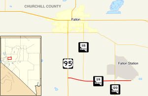
Route map:
Content deleted Content added
→top: USA is deprecated, per MOS:NOTUSA, and correct overlinking of common places using AWB |
|||
| Line 58: | Line 58: | ||
{{Portal|Nevada}} |
{{Portal|Nevada}} |
||
{{Reflist}} |
{{Reflist}} |
||
{{commonscat|Nevada State Route 119}} |
|||
[[Category:State highways in Nevada|119]] |
[[Category:State highways in Nevada|119]] |
||
[[Category:Lincoln Highway]] |
[[Category:Lincoln Highway]] |
||
Revision as of 14:25, 5 March 2017
| Berney Road | ||||
 Nevada State Route 119, highlighted in red. | ||||
| Route information | ||||
| Maintained by NDOT | ||||
| Length | 4.137 mi[1] (6.658 km) | |||
| Existed | December 31, 1991–present | |||
| Major junctions | ||||
| West end | ||||
| East end | Beach Road in the southwest corner of NAS Fallon | |||
| Location | ||||
| Country | United States | |||
| State | Nevada | |||
| Counties | Churchill | |||
| Highway system | ||||
| ||||
| ||||
State Route 119 is a state highway in Nevada, United States. It connects U.S. Route 95 east to NAS Fallon as part of Berney Road.

Major intersections
The entire route is in Churchill County.
| Location | mi | km | Destinations | Notes | |
|---|---|---|---|---|---|
| | 0.00 | 0.00 | |||
| | Southern terminus of NV 115 | ||||
| | Northern terminus of NV 120 | ||||
| | 4.137 | 6.658 | Beach Road | Gate to NAS Fallon | |
| 1.000 mi = 1.609 km; 1.000 km = 0.621 mi | |||||
References
KML is from Wikidata
Wikimedia Commons has media related to Nevada State Route 119.

