Saint Joseph, Barbados: Difference between revisions
Appearance
Content deleted Content added
→top: punctuation |
JJMC89 bot (talk | contribs) Migrate {{Infobox settlement}} coordinates parameters to {{Coord}}, see Wikipedia:Coordinates in infoboxes |
||
| Line 7: | Line 7: | ||
| mapsize = frameless |
| mapsize = frameless |
||
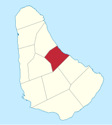
| map_caption = Map of Barbados showing the Saint Joseph parish |
| map_caption = Map of Barbados showing the Saint Joseph parish |
||
| ⚫ | |||
| latd = 13 |latm = 12|lats = |latNS = N |
|||
| longd = 59 |longm = 32|longs = |longEW = W |
|||
| ⚫ | |||
| coordinates_display = title |
|||
| coordinates_region = BB |
|||
| subdivision_type = Country |
| subdivision_type = Country |
||
| subdivision_name = [[Barbados]] |
| subdivision_name = [[Barbados]] |
||
Revision as of 19:13, 5 March 2017
Saint Joseph | |
|---|---|
 | |
 Map of Barbados showing the Saint Joseph parish | |
| Coordinates: 13°12′N 59°32′W / 13.200°N 59.533°W | |
| Country | Barbados |
| Largest city | Bathsheba |
| Government | |
| • Type | Parliamentary democracy |
| • Parliamentry seats | 1 |
| Area | |
• Total | 26 km2 (10 sq mi) |
| Population (2010 census) | |
• Total | 6,620 |
| • Density | 250/km2 (660/sq mi) |
The parish of Saint Joseph is a parish of Barbados on the eastern side of the island. The parish is home to two of the more notable botanic gardens in the country - Flower Forest and Andromeda Gardens. Parts of St. Joseph are also referred to as the Scotland District, a reference to the appearance of the landscape.
The main town in the parish is Bathsheba.
One of the highest points in the island is Chimborazo in Saint Joseph. Saint Joseph is also the home of the "Soup Bowl" where international surfing competitions are held.
Geography
Settlements
3
Parishes bordering Saint Joseph
- Saint Andrew - North
- Saint George - South
- Saint John - Southeast
- Saint Thomas - West
Wikimedia Commons has media related to Saint Joseph, Barbados.
