Sianky: Difference between revisions
Appearance
Content deleted Content added
removed Category:Villages in Lviv Oblast; added Category:Villages in Turka Raion using HotCat |
JJMC89 bot (talk | contribs) Migrate {{Infobox settlement}} coordinates parameters to {{Coord}}, see Wikipedia:Coordinates in infoboxes |
||
| Line 16: | Line 16: | ||
| subdivision_type2 = [[Raion]] |
| subdivision_type2 = [[Raion]] |
||
| subdivision_name2 = [[Turka Raion|Turka]] |
| subdivision_name2 = [[Turka Raion|Turka]] |
||
| coordinates = {{coord|49|01|30|N|22|54|00|E|display=inline}} |
|||
| latd = 49 |
|||
| latm = 01 |
|||
| lats = 30 |
|||
| latNS = N |
|||
| longd = 22 |
|||
| longm = 54 |
|||
| longs = 00 |
|||
| longEW = E |
|||
| pushpin_map = Ukraine Lviv Oblast |
| pushpin_map = Ukraine Lviv Oblast |
||
| pushpin_label_position = |
| pushpin_label_position = |
||
Revision as of 14:32, 8 March 2017
Sianky
Сянки | |
|---|---|
Village | |
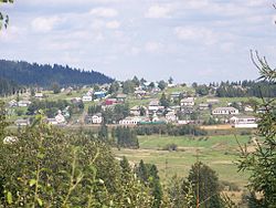
 Landskape of Sianky | |
| Coordinates: 49°01′30″N 22°54′00″E / 49.02500°N 22.90000°E | |
| Country | |
| Oblast | |
| Raion | Turka |
Area | 0.7 km2 (0.3 sq mi) |
| Population | 580 |
Sianky (Template:Lang-uk; Template:Lang-pl) is a village in Lviv Oblast, Ukraine on the San River. It is located a few kilometers from the border with Poland, in the south-eastern part of Bieszczady. During 966 - 1018, 1340 - 1772 and 1918 - 1939 Sianky was the part of Poland, while during 1772 - 1918 it belonged to the Austrian empire (later Austrian-Hungarian empire when double monarchy was introduced in Austria). On September 17, 1939, Sianky was incorporated into the Soviet Union, and since the collapse of the Soviet Union in 1991, is part of independent Ukraine.
A railway station of Lviv-Uzhhorod railroad is located in Sianky. The village's population was about 500 in 2001.


