Gmina Adamów, Łuków County: Difference between revisions
Rescuing 1 sources and tagging 0 as dead. #IABot (v1.2.7.1) |
JJMC89 bot (talk | contribs) Migrate {{Infobox settlement}} coordinates parameters to {{Coord}}, see Wikipedia:Coordinates in infoboxes |
||
| Line 9: | Line 9: | ||
| image_map = Lub Lukowski Adamow.png |
| image_map = Lub Lukowski Adamow.png |
||
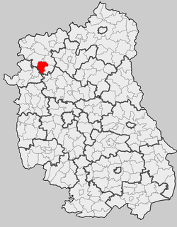
| map_caption = Location within the county and voivodeship |
| map_caption = Location within the county and voivodeship |
||
| coordinates_display = inline,title |
|||
| coordinates_region = PL |
|||
| subdivision_type = Country |
| subdivision_type = Country |
||
| subdivision_name = {{POL}} |
| subdivision_name = {{POL}} |
||
| Line 21: | Line 19: | ||
| population_density_km2 = auto |
| population_density_km2 = auto |
||
| coor_pinpoint = Adamów |
| coor_pinpoint = Adamów |
||
| coordinates = {{coord|51|45|N|22|15|E|region:PL|display=inline,title}} |
|||
| latd = 51 |
|||
| latm = 45 |
|||
| lats = |
|||
| latNS = N |
|||
| longd = 22 |
|||
| longm = 15 |
|||
| longs = |
|||
| longEW = E |
|||
| seat = [[Adamów, Łuków County|Adamów]] |
| seat = [[Adamów, Łuków County|Adamów]] |
||
| website = http://www.adamow.pl/ <ref>{{cite web|title=Biuletyn Informacji Publicznej - Urząd Gminy Adamów|url=https://adamow.bip.lubelskie.pl/index.php?id=6|website=Biuletyn Informacji Publicznej|publisher=Gmina Adamów|accessdate=23 June 2016|archiveurl=https://web.archive.org/web/20160501094231/http://adamow.bip.lubelskie.pl/index.php?id=6|archivedate=1 May 2016|language=Polish}}</ref>}} |
| website = http://www.adamow.pl/ <ref>{{cite web|title=Biuletyn Informacji Publicznej - Urząd Gminy Adamów|url=https://adamow.bip.lubelskie.pl/index.php?id=6|website=Biuletyn Informacji Publicznej|publisher=Gmina Adamów|accessdate=23 June 2016|archiveurl=https://web.archive.org/web/20160501094231/http://adamow.bip.lubelskie.pl/index.php?id=6|archivedate=1 May 2016|language=Polish}}</ref>}} |
||
Revision as of 19:29, 18 March 2017
Gmina Adamów
Adamów Commune | |
|---|---|
 Location within the county and voivodeship | |
| Coordinates (Adamów): 51°45′N 22°15′E / 51.750°N 22.250°E | |
| Country | |
| Voivodeship | Lublin |
| County | Łuków |
| Seat | Adamów |
| Area | |
• Total | 98.89 km2 (38.18 sq mi) |
| Population (2006) | |
• Total | 5,801 |
| • Density | 59/km2 (150/sq mi) |
| Website | http://www.adamow.pl/ [1] |
Gmina Adamów is a rural gmina (administrative district) in Łuków County, Lublin Voivodeship, in eastern Poland. Its seat is the village of Adamów, which lies approximately 21 kilometres (13 mi) south-west of Łuków and 60 km (37 mi) north of the regional capital Lublin.
The gmina covers an area of 98.89 square kilometres (38.2 sq mi), and as of 2006 its total population is 5,801.
Neighbouring gminas
Gmina Adamów is bordered by the gminas of Jeziorzany, Krzywda, Nowodwór, Serokomla, Ułęż and Wojcieszków.
Villages
The gmina contains the following villages with the status of sołectwo: Adamów (divided into 2 sołectwos: Adamów I and Adamów II), Budziska, Dąbrówka, Ferdynandów, Gułów, Helenów, Hordzieżka, Kalinowy Dół, Konorzatka, Lipiny, Sobiska, Turzystwo, Władysławów, Wola Gułowska, Zakępie and Żurawiec.
There is one village without sołectwo status: Natalin, which belongs to the sołectwo of Żurawiec.
See also
References
- ^ "Biuletyn Informacji Publicznej - Urząd Gminy Adamów". Biuletyn Informacji Publicznej (in Polish). Gmina Adamów. Archived from the original on 1 May 2016. Retrieved 23 June 2016.


