Wuda District: Difference between revisions
Appearance
Content deleted Content added
No edit summary |
JJMC89 bot (talk | contribs) Migrate {{Infobox settlement}} coordinates parameters to {{Coord}}, see Wikipedia:Coordinates in infoboxes |
||
| Line 102: | Line 102: | ||
|timezone = [[China Standard Time|China Standard]] |
|timezone = [[China Standard Time|China Standard]] |
||
|utc_offset = +8 |
|utc_offset = +8 |
||
|coordinates = {{coord|39|30|21|N|106|43|03|E|region:CN-15|display=inline,title}} |
|||
|coordinates_region = CN-15 |
|||
|coordinates_display = inline,title |
|||
|latd= 39|latm= 30 |lats= 21 |latNS= N |
|||
|longd=106 |longm=43 |longs=03 |longEW=E |
|||
<!-- Area/postal codes & others --------> |
<!-- Area/postal codes & others --------> |
||
|postal_code_type = Postal code <!-- enter ZIP code, Postcode, Post code, Postal code... --> |
|postal_code_type = Postal code <!-- enter ZIP code, Postcode, Post code, Postal code... --> |
||
Revision as of 20:24, 21 March 2017
Wuda
乌达区 • ᠤᠳᠠᠲᠣᠭᠣᠷᠢᠭ | |
|---|---|
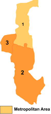
 Wuda is the division labeled '3' on this map of Wuhai City | |
| Coordinates: 39°30′21″N 106°43′03″E / 39.50583°N 106.71750°E | |
| Country | People's Republic of China |
| Prefecture-level city | Wuhai |
| Time zone | UTC+8 (China Standard) |
Wuda District (Mongolian: ᠤᠳᠠ ᠲᠣᠭᠣᠷᠢᠭ Уда тоори Uda toɣoriɣ; simplified Chinese: 乌达区; traditional Chinese: 烏達區; pinyin: Wūdá Qū) is a district of the city of Wuhai, Inner Mongolia, People's Republic of China, located on the west (left) bank of the Yellow River.
