Roden, Netherlands: Difference between revisions
Appearance
Content deleted Content added
ce population |
JJMC89 bot (talk | contribs) Migrate {{Infobox settlement}} coordinates parameters to {{Coord}}, see Wikipedia:Coordinates in infoboxes |
||
| Line 4: | Line 4: | ||
|image_skyline = RodenChurch.jpg |
|image_skyline = RodenChurch.jpg |
||
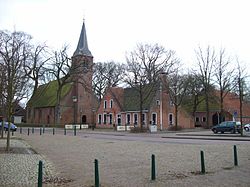
|image_caption = Roden in 2007 |
|image_caption = Roden in 2007 |
||
|coordinates_region = NL-DR |
|||
|subdivision_type = Country |
|subdivision_type = Country |
||
|subdivision_name = [[Netherlands]] |
|subdivision_name = [[Netherlands]] |
||
| Line 20: | Line 19: | ||
| pushpin_map_alt = |
| pushpin_map_alt = |
||
| pushpin_map_caption = Location in the province of [[Drenthe]] in the [[Netherlands]] |
| pushpin_map_caption = Location in the province of [[Drenthe]] in the [[Netherlands]] |
||
|coordinates = {{coord|53|8|18|N|6|25|57|E|region:NL-DR|display=inline}} |
|||
|latNS = N |
|||
|longEW = E |
|||
|latd = 53 |
|||
|latm = 8 |
|||
|lats = 18 |
|||
|longd = 6 |
|||
|longm = 25 |
|||
|longs = 57 |
|||
}} |
}} |
||
Revision as of 15:26, 27 March 2017
Roden | |
|---|---|
 Roden in 2007 | |
Location in the province of Drenthe in the Netherlands | |
| Coordinates: 53°8′18″N 6°25′57″E / 53.13833°N 6.43250°E | |
| Country | Netherlands |
| Province | Drenthe |
| Municipality | Noordenveld |
| Population | 15,000 |
Roden (Dutch pronunciation: [ˈroːdən] ) is a village in the Dutch province of Drenthe. It is located in the municipality of Noordenveld, about 16 (10 miles) km southwest of Groningen. Roden has 15,000 citizens.
Roden was a separate municipality until 1998, before it merged into the municipality of Noordenveld, during the last municipal reorganisations.[1]
Notable people
- Peter Dijkstra (born 1978), conductor
References
External links
 Media related to Roden (Noordenveld) at Wikimedia Commons
- Template:Kuyper Map of the former municipality in 1868.

