Rocky Mountain Metropolitan Airport: Difference between revisions
enhanced map |
|||
| Line 96: | Line 96: | ||
* {{FAA-diagram|05612}} |
* {{FAA-diagram|05612}} |
||
* {{FAA-procedures|BJC}} |
* {{FAA-procedures|BJC}} |
||
* [https://acukwik.com/Airport-Info/KBJC AC-U-KWIK information for KBJC] |
|||
* {{US-airport-ga|BJC}} |
* {{US-airport-ga|BJC}} |
||
Revision as of 13:43, 30 March 2017
Rocky Mountain Metropolitan Airport | |||||||||||||||||||
|---|---|---|---|---|---|---|---|---|---|---|---|---|---|---|---|---|---|---|---|
 The terminal building. | |||||||||||||||||||
| Summary | |||||||||||||||||||
| Airport type | Public | ||||||||||||||||||
| Owner/Operator | Jefferson County | ||||||||||||||||||
| Serves | Denver, Colorado | ||||||||||||||||||
| Elevation AMSL | 5,673 ft / 1,729 m | ||||||||||||||||||
| Coordinates | 39°54′32″N 105°07′02″W / 39.90889°N 105.11722°W | ||||||||||||||||||
| Maps | |||||||||||||||||||
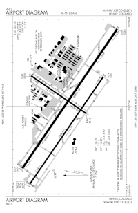
 FAA airport diagram | |||||||||||||||||||
 | |||||||||||||||||||
| Runways | |||||||||||||||||||
| |||||||||||||||||||
| Statistics (2015) | |||||||||||||||||||
| |||||||||||||||||||
Rocky Mountain Metropolitan Airport (IATA: BJC, ICAO: KBJC, FAA LID: BJC) is a public-use airport located near Broomfield, Colorado, United States. The airport is owned and operated by Jefferson County and is situated midway between Denver and Boulder on U.S. Highway 36. It is located sixteen miles northwest of the central business district of Denver,[1] and is the closest airport to downtown Denver.[2] The airport covers 1,700 acres (688 ha) and has three runways.[1] Formerly known as Jefferson County Airport or Jeffco Airport, the airport was renamed Rocky Mountain Metropolitan Airport on October 10, 2006 [2] although it is sometimes referred to as Rocky Mountain Regional Airport, e.g. 2007-2012 county planning documents.
This airport is included in the National Plan of Integrated Airport Systems for 2011–2015, which categorized it as a reliever airport.[3] It is home to a large general aviation population including a fair amount of corporate traffic and several flight schools. The airport's proximity to the nearby Interlocken business district contributes to its business traveler clientele. It has a control tower on 118.6 (Local) and 121.7 (Ground) that is open from 0600 to 2200 local time. ATIS/AWOS broadcasts on 126.25. There are three runways - 12/30 Left and Right and 3/21. The runway numbers were changed in November 2014 to reflect a change in magnetic variation. One fixed-base operator (FBO) offers fuel and other services. Two restaurants, E's Just Good Eats and Blue Sky Bistro, are on the field, along with a pilot's lounge in the Signature FBO and a passenger terminal lobby. The Hilltop Inn, a bed & breakfast, and its companion restaurant, Wildflowers ("Authentic U.K. Fare"), is located on the property.
On February 7, 2012 the Federal Aviation Administration dedicated a new $23.7 million, state-of-the-art airport traffic control tower, located south of the airport runways. The new facility includes a 124-foot-tall control tower topped by a 525-square-foot tower cab with four air traffic controller positions and one supervisor position. A 6,000 square-foot, single-story base building houses administrative offices, training rooms, and equipment rooms.
The USDA Forest Service maintains its Jefferson County Tanker Base at the airport.
On July 13, 2016, Pilatus Aircraft broke ground on a new 188,000 sq. ft. North American completion center for the new PC-24 business jet. It is expected to be operational in the Spring 2018.
Facilities and aircraft

Rocky Mountain Metropolitan Airport covers an area of 1,700 acres (688 ha) at an elevation of 5,673 feet (1,729 m) above mean sea level. It has three asphalt paved runways: 12L/30R is 9,000 by 100 feet (2,743 x 30 m); 12R/30L is 7,002 by 75 feet (2,134 x 23 m); 3/21 is 3,600 by 75 feet (1,097 x 23 m).[1]
The airport's three runways, previously 11L/29R, 11R/29L, and 2/20, were renumbered in November 2014 in order to align them with magnetic directions. At the same time, the primary runway (12L/30R) underwent an $8.83 million renovation.[4]
For the 12-month period ending September 30, 2016, the airport had 145,329 aircraft operations, an average of 398 per day: 92% general aviation, 4% air taxi, 3% military and <1% air carrier. At that time there were 360 aircraft based at this airport: 70% single-engine, 17% multi-engine, 9% jet, and 4% helicopter.[1]
Airline and destination
The airport was formerly a hub for Pet Airways before ceasing all flights in early 2013.
| Airlines | Destinations |
|---|---|
| Denver Air Connection operated by Key Lime Air | Grand Junction[5] |
See also
References
- ^ a b c d e FAA Airport Form 5010 for BJC PDF. Federal Aviation Administration. Effective April 5, 2012.
- ^ a b "Jeffco Commissioners to Rename Jeffco Airport as Rocky Mountain Metropolitan Airport". 2006-10-10.
- ^
"2011–2015 NPIAS Report, Appendix A (PDF, 2.03 MB)" (PDF). National Plan of Integrated Airport Systems. Federal Aviation Administration. October 4, 2010.
{{cite web}}: External link in|work= - ^ "Runway to shut down at Rocky Mountain Metro". General Aviation News. April 10, 2014.
- ^ Denver Air Connection - Destinations, Retrieved 2013-11-18
External links
- Rocky Mountain Metropolitan Airport (official site)
- Rocky Mountain Metropolitan Airport (BJC) at Colorado DOT airport directory
- USDA Forest Service Jefferson County Tanker Base
- Ten-Hi Flyers flying club
- Rocky Mountain Airshow
- Classic Airport Tower A Memory
- Runway Grill
- Blue Sky Bistro
- Hilltop Inn/Wildflowers Restaurant
- FAA Airport Diagram (PDF), effective December 26, 2024
- FAA Terminal Procedures for BJC, effective December 26, 2024
- AC-U-KWIK information for KBJC
- Resources for this airport:
- FAA airport information for BJC
- AirNav airport information for KBJC
- ASN accident history for BJC
- FlightAware airport information and live flight tracker
- NOAA/NWS weather observations: current, past three days
- SkyVector aeronautical chart, Terminal Procedures


