Vermont Route 14: Difference between revisions
expand |
wrong junctions |
||
| Line 10: | Line 10: | ||
|direction_a=South |
|direction_a=South |
||
|starting_terminus=[[Image:US 4.svg|20px]][[Image:US 5.svg|20px]] [[U.S. Route 4|US 4]]/[[U.S. Route 5|US 5]] in [[White River Junction]] |
|starting_terminus=[[Image:US 4.svg|20px]][[Image:US 5.svg|20px]] [[U.S. Route 4|US 4]]/[[U.S. Route 5|US 5]] in [[White River Junction]] |
||
|junction=[[Image: |
|junction=[[Image:US 302.svg|25px]] [[US 302]] in [[Barre City, Vermont|Barre]]<br>[[Image:US 2.svg|20px]] [[US 2]] in [[East Montpelier, Vermont|East Montpelier]]<br>[[Image:Vermont 15.svg|20px]] [[Vermont Route 15|VT 15]] in [[Hardwick, Vermont|Hardwick]] |
||
|direction_b=North |
|direction_b=North |
||
|ending_terminus=[[Image:Vermont 100.svg|25px]] [[Vermont Route 100|VT 100]] in [[Newport, Vermont|Newport]] |
|ending_terminus=[[Image:Vermont 100.svg|25px]] [[Vermont Route 100|VT 100]] in [[Newport, Vermont|Newport]] |
||
Revision as of 02:30, 26 September 2006
 | ||||
| Route information | ||||
| Maintained by VTrans | ||||
| Length | 110.25 mi[1] (177.43 km) | |||
| Major junctions | ||||
| Location | ||||
| Country | United States | |||
| State | Vermont | |||
| Highway system | ||||
| ||||
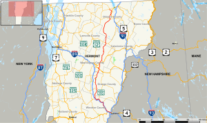
Vermont Route 14 is a north-south state highway in northeastern Vermont. Its southern terminus is at U.S. Route 4/U.S. Route 5 in White River Junction and its northern terminus is at Route 100 in Newport. It runs for 108.15 miles.
The route number dates back from 1922 when it was part of New England Interstate Route 14. The original route ran from White River Junction, through Montpelier, up to Burlington. The portion of the old route from Montpelier to Burlington was assigned to U.S. Route 2 in 1926. At the same time, Route 14 was truncated to end at Barre (east of Montpelier).
In the 1960s, the northern terminus of Vermont Route 12 was relocated, and at the same time, the related route Vermont Route 12B was decomissioned. Part of the routing of old Route 12 (from Montpelier to Hardwick), and the entire routing of old Route 12B (Hardwick to Coventry), was assigned to an extended Route 14.
Major intersections
| County | Location | mi | km | Destinations | Notes |
|---|---|---|---|---|---|
| Windsor | White River Junction | 0.0 | 0.0 | ||
| Sharon | 12.9 | 20.8 | |||
| Royalton | 17.8 | 28.6 | |||
| 21.3 | 34.3 | ||||
| Orange | Randolph | 30.4 | 48.9 | ||
| Brookfield | 36.8 | 59.2 | |||
| Williamstown | 44.3 | 71.3 | |||
| Washington | Town of Barre | 48.4 | 77.9 | ||
| Barre City | 50.2 | 80.8 | Southern terminus of duplex. | ||
| 50.6 | 81.4 | Northern terminus of duplex. | |||
| 50.6 | 81.4 | ||||
| East Montpelier | 55.7 | 89.6 | 0.2 mi overlap | ||
| 59.0 | 95.0 | ||||
| Caledonia | Hardwick | 75.3 | 121.2 | Southern terminus of duplex. | |
| 76.3 | 122.8 | Northern terminus of duplex. | |||
| Orleans | Irasburg | 100.1 | 161.1 | Southern terminus of duplex. | |
| 101.3 | 163.0 | Northern terminus of duplex. | |||
| Coventry | 104.9 | 168.8 | Southern terminus of duplex. | ||
| 105.4 | 169.6 | Northern terminus of duplex. | |||
| Town of Newport | 110.2 | 177.3 | |||
| Concurrency terminus • Closed • Unopened | |||||

