Ance Féas: Difference between revisions
Appearance
Content deleted Content added
img, commonscat |
ibx param |
||
| Line 1: | Line 1: | ||
{{Infobox French commune |
{{Infobox French commune |
||
|name = Ance Féas |
|name = Ance Féas |
||
|commune status = [[Communes of France|Commune]] |
|||
|image = Féas (Pyr-Atl, Fr) église.JPG |
|image = Féas (Pyr-Atl, Fr) église.JPG |
||
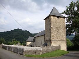
|caption = The church of Saint-Barthélemy, in Féas |
|caption = The church of Saint-Barthélemy, in Féas |
||
Revision as of 12:50, 10 May 2017
Ance Féas | |
|---|---|
 The church of Saint-Barthélemy, in Féas | |
| Coordinates: 43°09′25″N 0°41′17″W / 43.157°N 0.688°W | |
| Country | France |
| Region | Nouvelle-Aquitaine |
| Department | Pyrénées-Atlantiques |
| Arrondissement | Oloron-Sainte-Marie |
| Canton | Oloron-Sainte-Marie-1 |
| Intercommunality | vallée de Barétous |
Area 1 | 23.83 km2 (9.20 sq mi) |
| Population (2013) | 642 |
| • Density | 27/km2 (70/sq mi) |
| Time zone | UTC+01:00 (CET) |
| • Summer (DST) | UTC+02:00 (CEST) |
| INSEE/Postal code | 64225 /64570 |
| 1 French Land Register data, which excludes lakes, ponds, glaciers > 1 km2 (0.386 sq mi or 247 acres) and river estuaries. | |
Ance Féas is a commune in the department of Pyrénées-Atlantiques, southwestern France. The municipality was established on 1 January 2017 by merger of the former communes of Féas (the seat) and Ance.[1]
See also
References
Wikimedia Commons has media related to Ance Féas.
- ^ Arrêté préfectoral 19 July 2016 Template:Fr


