Garacad: Difference between revisions
Appearance
Content deleted Content added
No edit summary |
move coordinates to infobox |
||
| Line 1: | Line 1: | ||
{{Infobox settlement |
{{Infobox settlement |
||
|official_name =Garacad |
| official_name = Garacad |
||
| |
| native_name = |
||
| |
| other_name = |
||
| |
| settlement_type = Town |
||
| |
| image_skyline = Garacadhoriz.jpg |
||
| |
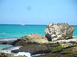
| image_caption = The Garacad horizon |
||
| |
| image_flag = |
||
| |
| image_seal = |
||
| |
| nickname = |
||
| |
| motto = |
||
| |
| image_map = |
||
| |
| map_caption = |
||
| ⚫ | |||
|seal_size = |
|||
| |
| pushpin_map = Somalia |
||
| ⚫ | |||
|mapsize = |
|||
| ⚫ | |||
|map_caption = |
|||
| |
| subdivision_type = Country |
||
| ⚫ | |||
| ⚫ | |||
|pushpin_mapsize = |
|||
| ⚫ | |||
|subdivision_type =Country |
|||
| ⚫ | |||
|subdivision_type2 =[[Administrative divisions of Somalia|Region]] |
|||
|subdivision_name2 =[[Mudug]] |
|||
| subdivision_type1 = [[States and regions of Somalia|Regional State]] |
| subdivision_type1 = [[States and regions of Somalia|Regional State]] |
||
| subdivision_name1 = {{flag|Puntland}} |
| subdivision_name1 = {{flag|Puntland}} |
||
|subdivision_type2 = |
| subdivision_type2 = [[Administrative divisions of Somalia|Region]] |
||
|subdivision_name2 = |
| subdivision_name2 = [[Mudug]] |
||
| ⚫ | |||
| ⚫ | |||
| |
| established_date = |
||
| |
| government_type = |
||
| ⚫ | |||
|leader_name = |
|||
| ⚫ | |||
| ⚫ | |||
| |
| leader_name = |
||
| |
| unit_pref = Metric |
||
| |
| area_footnotes = |
||
| |
| area_total_km2 = |
||
| |
| area_land_km2 = |
||
| elevation_footnotes = |
|||
| ⚫ | |||
| |
| elevation_m = |
||
| elevation_ft = |
|||
|population_footnotes = |
| population_footnotes = |
||
|population_note = |
|||
|population_total = |
| population_total = |
||
| population_as_of = |
|||
|population_density_km2 = |
| population_density_km2 = |
||
|timezone =[[East Africa Time|EAT]] |
|||
| |
| population_note = |
||
| |
| timezone = [[East Africa Time|EAT]] |
||
| |
| utc_offset = +3 |
||
| timezone_DST = |
|||
| ⚫ | |||
| |
| utc_offset_DST = |
||
| |
| postal_code_type = |
||
| |
| postal_code = +252 |
||
| |
| area_code = |
||
| |
| website = |
||
|area_code = |
|||
|blank_name = |
|||
|blank_info = |
|||
|website = |
|||
|footnotes = |
|||
}} |
}} |
||
'''Garacad''' is a tiny coastal village in the north-central [[Mudug]] region of [[Puntland]] a semi-autonomous state of [[Somalia]] |
'''Garacad''' is a tiny coastal village in the north-central [[Mudug]] region of [[Puntland]] a semi-autonomous state of [[Somalia]] |
||
| Line 67: | Line 56: | ||
==External links== |
==External links== |
||
*[http://www.bing.com/maps/?v=2&cp=6.944193~49.320133&lvl=18&sty=h Satellite view of Garacad (zoomable)] |
*[http://www.bing.com/maps/?v=2&cp=6.944193~49.320133&lvl=18&sty=h Satellite view of Garacad (zoomable)] |
||
{{coord|6|57|18|N|49|13|12|E|display=title|region:SO_type:city_source:GNS-enwiki}} |
|||
[[Category:Populated places in Mudug]] |
[[Category:Populated places in Mudug]] |
||


