Al-Shaykh Badr District: Difference between revisions
Appearance
Content deleted Content added
GreenC bot (talk | contribs) m Rescued 1 archive link; remove 1 link. Wayback Medic 2.1 |
Migrate infobox coordinates parameters to {{Coord}}, see Wikipedia:Coordinates in infoboxes |
||
| Line 8: | Line 8: | ||
| map_caption = Map of al-Shaykh Badr District within Tartus Governorate |
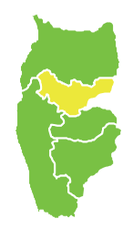
| map_caption = Map of al-Shaykh Badr District within Tartus Governorate |
||
| coor_pinpoint = [[al-Shaykh Badr]] |
| coor_pinpoint = [[al-Shaykh Badr]] |
||
| coordinates = {{coord|3=type:adm2nd_region:SY-TA|display=inline,title}} |
|||
| coordinates_type = type:adm2nd |
|||
| coordinates_display = inline,title |
|||
| coordinates_footnotes = |
|||
| coordinates_region = SY-TA |
|||
| coordinates_wikidata = yes |
|||
| subdivision_type = [[List of sovereign states|Country]] |
| subdivision_type = [[List of sovereign states|Country]] |
||
| subdivision_name = {{flag|Syria}} |
| subdivision_name = {{flag|Syria}} |
||
| subdivision_type1 = [[Governorates of Syria|Governorate]] |
| subdivision_type1 = [[Governorates of Syria|Governorate]] |
||
| subdivision_name1 = [[Tartus Governorate|Tartus]] |
| subdivision_name1 = [[Tartus Governorate|Tartus]] |
||
| Line 32: | Line 28: | ||
'''Al-Shaykh Badr District''' ({{lang-ar-at|منطقة الشيخ بدر|[[mantiqah|manṭiqat]] Al-Shaykh Badr}}) is a [[Districts of Syria|district]] of the [[Tartus Governorate]] in northwestern [[Syria]]. [[Administrative centre]] is the town of [[al-Shaykh Badr]]. At the 2004 census, the district had a population of 52,981.<ref name=census2004 /> |
'''Al-Shaykh Badr District''' ({{lang-ar-at|منطقة الشيخ بدر|[[mantiqah|manṭiqat]] Al-Shaykh Badr}}) is a [[Districts of Syria|district]] of the [[Tartus Governorate]] in northwestern [[Syria]]. [[Administrative centre]] is the town of [[al-Shaykh Badr]]. At the 2004 census, the district had a population of 52,981.<ref name=census2004 /> |
||
==Sub-districts== |
== Sub-districts == |
||
The district of al-Shaykh Badr is divided into three sub-districts or [[nahiyah|nawāḥī]] (population as of 2004<ref name=census2004 />): |
The district of al-Shaykh Badr is divided into three sub-districts or [[nahiyah|nawāḥī]] (population as of 2004<ref name=census2004 />): |
||
*[[Al-Shaykh Badr]] Nahiyah (ناحية الشيخ بدر): population 25,324.<ref>{{cite web|url=http://www.cbssyr.org/new%20web%20site/General_census/census_2004/NH/TAB10-25-2004.htm |title=Ash-Shaykh Badr nahiyah population |publisher=Cbssyr.org |date= |accessdate=2012-07-05 }}{{dead link|date=May 2017 |bot=InternetArchiveBot |fix-attempted=yes }}</ref> |
*[[Al-Shaykh Badr]] Nahiyah (ناحية الشيخ بدر): population 25,324.<ref>{{cite web|url=http://www.cbssyr.org/new%20web%20site/General_census/census_2004/NH/TAB10-25-2004.htm |title=Ash-Shaykh Badr nahiyah population |publisher=Cbssyr.org |date= |accessdate=2012-07-05 }}{{dead link|date=May 2017 |bot=InternetArchiveBot |fix-attempted=yes }}</ref> |
||
| Line 38: | Line 34: | ||
*[[Al-Qamsiyah]] Nahiyah (ناحية القمصية): population 14,095.<ref>{{cite web|url=http://www.cbssyr.org/new%20web%20site/General_census/census_2004/NH/TAB10-27-2004.htm |title=Al-Qomsiyah nahiyah population |publisher=Cbssyr.org |date= |accessdate=2012-07-05}}</ref> |
*[[Al-Qamsiyah]] Nahiyah (ناحية القمصية): population 14,095.<ref>{{cite web|url=http://www.cbssyr.org/new%20web%20site/General_census/census_2004/NH/TAB10-27-2004.htm |title=Al-Qomsiyah nahiyah population |publisher=Cbssyr.org |date= |accessdate=2012-07-05}}</ref> |
||
==References== |
== References == |
||
{{reflist|20em}} |
{{reflist|20em}} |
||
{{Syria-districts|Tartus=yes}} |
{{Syria-districts|Tartus=yes}} |
||
{{Tartus Governorate|shaykh}} |
{{Tartus Governorate|shaykh}} |
||
[[Category:Al-Shaykh Badr District]] |
[[Category:Al-Shaykh Badr District]] |
||
{{TartusSY-geo-stub}} |
{{TartusSY-geo-stub}} |
||
Revision as of 18:59, 4 June 2017
al-Shaykh Badr District
منطقة الشيخ بدر | |
|---|---|
 Map of al-Shaykh Badr District within Tartus Governorate | |
| Coordinates (al-Shaykh Badr): 34°59′N 36°05′E / 34.98°N 36.08°E | |
| Country | |
| Governorate | Tartus |
| Seat | al-Shaykh Badr |
| Subdistricts | 3 nawāḥī |
| Area | |
• Total | 214.34 km2 (82.76 sq mi) |
| Population (2004)[1] | |
• Total | 52,981 |
| • Density | 250/km2 (640/sq mi) |
| Geocode | SY1005 |
Al-Shaykh Badr District (Template:Lang-ar-at) is a district of the Tartus Governorate in northwestern Syria. Administrative centre is the town of al-Shaykh Badr. At the 2004 census, the district had a population of 52,981.[1]
Sub-districts
The district of al-Shaykh Badr is divided into three sub-districts or nawāḥī (population as of 2004[1]):
- Al-Shaykh Badr Nahiyah (ناحية الشيخ بدر): population 25,324.[2]
- Brummanet al-Mashayekh Nahiyah (ناحية برمانة المشايخ): population 13,562[3]
- Al-Qamsiyah Nahiyah (ناحية القمصية): population 14,095.[4]
References
- ^ a b c "2004 Census Data". UN OCHA. Retrieved 15 October 2015.
- ^ "Ash-Shaykh Badr nahiyah population". Cbssyr.org. Retrieved 2012-07-05.[permanent dead link]
- ^ "Brummanat al-Mashayekh nahiyah population". Cbssyr.org. Archived from the original on 2013-01-13. Retrieved 2012-07-05.
{{cite web}}: Unknown parameter|dead-url=ignored (|url-status=suggested) (help) - ^ "Al-Qomsiyah nahiyah population". Cbssyr.org. Retrieved 2012-07-05.

