Kamýk nad Vltavou: Difference between revisions
Appearance
Content deleted Content added
Magioladitis (talk | contribs) m clean using AWB |
update coords format in infobox |
||
| Line 60: | Line 60: | ||
|timezone_DST = [[Central European Summer Time|CEST]] |
|timezone_DST = [[Central European Summer Time|CEST]] |
||
|utc_offset_DST =+2 |
|utc_offset_DST =+2 |
||
|coordinates = <!-- {{coord|||region:CZ_type:city|display=inline,title}} --> |
|||
|latd=|latm=|lats=|latNS=N |
|||
|longd=|longm=|longs=|longEW=E |
|||
|coordinates_type = region:CZ_type:city |
|||
|coordinates_display = display=inline,title |
|||
|elevation_footnotes = <!--for references: use <ref> </ref> tags--> |
|elevation_footnotes = <!--for references: use <ref> </ref> tags--> |
||
|elevation_m = |
|elevation_m = |
||
Revision as of 16:25, 9 June 2017
This article needs additional citations for verification. (March 2017) |
Kamýk nad Vltavou | |
|---|---|
Municipality and village | |
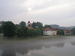
 Left bank of the Vltava River in Kamýk | |
 | |
| Country | |
| Region | Central Bohemian Region |
| District | Příbram District |
| Time zone | UTC+1 (CET) |
| • Summer (DST) | UTC+2 (CEST) |
Kamýk nad Vltavou is a village and municipality in Příbram District in the Central Bohemian Region of the Czech Republic. It lies on the Vltava River.

Notes
- This article was initially translated from the Czech Wikipedia.
Wikimedia Commons has media related to Kamýk nad Vltavou.
49°38′N 14°15′E / 49.633°N 14.250°E
References
- ^ "Z historie Kamyku". Obec Kamyk nad Vltavou. Kamyk nad Vltavou. Retrieved 2 February 2017.
