Nông Hạ: Difference between revisions
Appearance
Content deleted Content added
m Adding DEFAULTSORT to page with special characters (WP:CHECKWIKI error 37) + genfixes using AWB (7089) |
update coords format in infobox |
||
| Line 68: | Line 68: | ||
|timezone_DST = |
|timezone_DST = |
||
|utc_offset_DST = |
|utc_offset_DST = |
||
|coordinates = <!-- {{coord|||region:VN_type:city|display=inline,title}} --> |
|||
|latd=|latm=|lats= |latNS=N |
|||
|longd=|longm=|longs=|longEW=E |
|||
|coordinates_type = region:VN_type:city |
|||
|coordinates_display = display=inline,title |
|||
|elevation_footnotes = <!--for references: use <ref> </ref> tags--> |
|elevation_footnotes = <!--for references: use <ref> </ref> tags--> |
||
|elevation_m = |
|elevation_m = |
||
Revision as of 07:35, 10 June 2017
Nông Hạ | |
|---|---|
Commune and village | |
 | |
| Country | |
| Province | Bắc Kạn Province |
| District | Chợ Mới District |
| Time zone | UTC+7 (UTC+7) |
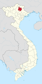
Nông Hạ is a commune (xã) and village in Chợ Mới District, Bắc Kạn Province, in Vietnam.
21°57′N 105°48′E / 21.950°N 105.800°E

