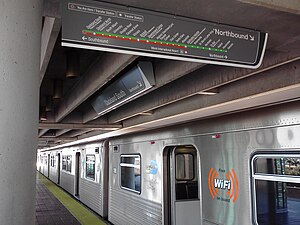
Dadeland South station: Difference between revisions
Appearance
Content deleted Content added
m Reverted edits by 162.244.162.142 (talk) to last version by Alexf |
No edit summary Tags: Mobile edit Mobile web edit |
||
| Line 6: | Line 6: | ||
| image_size=300px |
| image_size=300px |
||
| image_caption=Dadeland South platform |
| image_caption=Dadeland South platform |
||
| address=9150 Dadeland Boulevard<br>[[ |
| address=9150 Dadeland Boulevard<br>[[Miami, Florida]] 33156 |
||
| coordinates={{coord|25|41|6|N|80|18|49|W |type:railwaystation_region:US-FL |display=inline,title}} |
| coordinates={{coord|25|41|6|N|80|18|49|W |type:railwaystation_region:US-FL |display=inline,title}} |
||
| line={{Rail color box| system=MDM| line=Green}}{{rail color box| system=MDM| line=Orange}} |
| line={{Rail color box| system=MDM| line=Green}}{{rail color box| system=MDM| line=Orange}} |
||
| Line 30: | Line 30: | ||
}} |
}} |
||
'''Dadeland South station''' is a [[Interchange station|transfer station]] on the [[Metrorail (Miami-Dade County)|Metrorail]] [[rapid transit]] system in the [[Dadeland]] district of [[ |
'''Dadeland South station''' is a [[Interchange station|transfer station]] on the [[Metrorail (Miami-Dade County)|Metrorail]] [[rapid transit]] system in the [[Dadeland]] district of [[Miami, Florida]]. It is the southern terminus of the system. This station is located near the intersection of Dadeland Boulevard and Datran Boulevard, adjacent to [[South Dixie Highway]] ([[U.S. Route 1 in Florida|US 1]]), three blocks southwest of [[Kendall Drive]] and [[Dadeland Mall]], and just east of the US 1–[[Florida State Road 826|Palmetto Expressway (SR 826)]] junction. It opened to service May 20, 1984. |
||
==Places of interest== |
==Places of interest== |
||
Revision as of 22:32, 28 June 2017
| Metrorail metro station | |||||||||||||||
 Dadeland South platform | |||||||||||||||
| General information | |||||||||||||||
| Location | 9150 Dadeland Boulevard Miami, Florida 33156 | ||||||||||||||
| Coordinates | 25°41′6″N 80°18′49″W / 25.68500°N 80.31361°W | ||||||||||||||
| Owned by | Miami-Dade County | ||||||||||||||
| Line(s) | Lua error: expandTemplate: template "MDM color" does not exist.Lua error: expandTemplate: template "MDM color" does not exist. | ||||||||||||||
| Platforms | 1 island platform | ||||||||||||||
| Tracks | 2 | ||||||||||||||
| Connections | |||||||||||||||
| Construction | |||||||||||||||
| Parking | Garage (1060 spaces), surface lot (200 spaces) | ||||||||||||||
| Bicycle facilities | Rack | ||||||||||||||
| Accessible | Yes | ||||||||||||||
| Other information | |||||||||||||||
| Station code | DLS | ||||||||||||||
| History | |||||||||||||||
| Opened | May 20, 1984 | ||||||||||||||
| Passengers | |||||||||||||||
| 2012 | 2.2 million[1] | ||||||||||||||
| Services | |||||||||||||||
| |||||||||||||||
Dadeland South station is a transfer station on the Metrorail rapid transit system in the Dadeland district of Miami, Florida. It is the southern terminus of the system. This station is located near the intersection of Dadeland Boulevard and Datran Boulevard, adjacent to South Dixie Highway (US 1), three blocks southwest of Kendall Drive and Dadeland Mall, and just east of the US 1–Palmetto Expressway (SR 826) junction. It opened to service May 20, 1984.
Places of interest
- Downtown Dadeland
- Dadeland Mall
- Dadeland Marriott
- Datran Towers Complex
- Metropolis at Dadeland
- Town Center One
- South Miami-Dade Busway
- The Falls (via Busway to SW 136 St)
Transit connections
Metrobus
| Route # | Route Name | Route Map | Note |
|---|---|---|---|
| 31 | Busway Local (Southland Mall Park & Ride via Busway to SW 112 Ave) | Map | |
| 34 | Busway Flyer (Florida City via Busway, US 1, and Krome Avenue) | Map | Weekday rush hour service only |
| 38 | Busway MAX (Florida City via Busway and US 1) | Map | |
| 52 | Dadeland North station ↔ South Miami-Dade Health Center via Busway | Map | |
| 73 | Miami Gardens Drive at NW 68 Avenue via Ludlam Road (West 67 Ave) and Milam Dairy Road (West 72 Ave) | Map | |
| 88 | SW 157 Ave via Kendall Drive (South 88 St) | Map | |
| 136 | SW 112 St & 137 Ave via Busway and southern Miami-Dade County or Douglas Road station via Old Cutler Road | Map | Weekday service only |
| 252 | Coral Reef MAX (Country Walk or SW 162 Ave [252A] via Coral Reef Drive) | Map | |
| 287 | Saga Bay MAX (South Dade via Busway, Galloway Road and South 216 St) | Map | Weekday rush hour only |
| 500 | Midnight Owl (Government Center Downtown Bus Terminal via Metrorail) | Map | Overnight service only |
References
External links
 Media related to Dadeland South metro station at Wikimedia Commons
- MDT – Metrorail Stations
- Station from Dadeland Boulevard from Google Map Street View

