Schaeffer Fire: Difference between revisions
Tags: Mobile edit Mobile web edit |
m typo; mos |
||
| Line 21: | Line 21: | ||
}} |
}} |
||
The '''Schaeffer fire''' is a wildfire currently burning in Kern River Ranger District of the [[Sequoia National Forest]] in [[Tulare County]], [[California]]. Determined to have caused by a lightning strike on June 24, the fire crept through the old burn area of the 2002 [[McNally_Fire|McNally fire]] burn area for several days before |
The '''Schaeffer fire''' is a wildfire currently burning in Kern River Ranger District of the [[Sequoia National Forest]] in [[Tulare County]], [[California]]. Determined to have caused by a lightning strike on June 24, the fire crept through the old burn area of the 2002 [[McNally_Fire|McNally fire]] burn area for several days before growing to over 580 acres on June 28.<ref name=InciWeb2>{{cite web|title=Schaeffer Fire Announcement|url=https://inciweb.nwcg.gov/incident/article/5285/35928/|website=[[InciWeb]]|accessdate=June 28, 2017}}</ref> Since then, the fire has ballooned to over {{convert|11,750|acres}} in size and is rapidly burning in a north-easterly direction.<ref name=InciWeb/> There is an estimate of only 10 percent containment on the Schaeffer fire as of July 7. |
||
==Events== |
==Events== |
||
Reported, Saturday, June 24, at approximately 4:16 p.m., the soon to be named Sacheffer fire was noted to be burning in whitethorn, dead and down logs and needle cast.<ref name=InciWeb/>As smoke from the fire has been seen all throughout the Lake Isabella area, the fire, which is burning at about 7,300 feet in elevation, has caused the San Joaquin Valley Air Pollution Control District to alert a smoke advisory in the area.<ref name="Fresno Bee-Lightning Strike">{{cite web|last1=Rodriguez-Delgado|first1=Cresencio|title=A lightning strike started a fire. Now dangerous smoke has reached this community|url=http://www.fresnobee.com/news/local/article158719864.html |work=[[The_Fresno_Bee|The Fresno Bee]]|access-date=28 June 2017}}</ref> The fire is burning near the community of [[Kennedy_Meadows, California|Kennedy Meadows]] in the Sequoia National Forest, however it was not threatening any structures at this time.<ref name="Fresno Bee-Lightning Strike"/> |
Reported, Saturday, June 24, at approximately 4:16 p.m., the soon to be named Sacheffer fire was noted to be burning in whitethorn, dead and down logs and needle cast.<ref name=InciWeb/>As smoke from the fire has been seen all throughout the Lake Isabella area, the fire, which is burning at about 7,300 feet in elevation, has caused the San Joaquin Valley Air Pollution Control District to alert a smoke advisory in the area.<ref name="Fresno Bee-Lightning Strike">{{cite web|last1=Rodriguez-Delgado|first1=Cresencio|title=A lightning strike started a fire. Now dangerous smoke has reached this community|url=http://www.fresnobee.com/news/local/article158719864.html |work=[[The_Fresno_Bee|The Fresno Bee]]|access-date=28 June 2017}}</ref> The fire is burning near the community of [[Kennedy_Meadows, California|Kennedy Meadows]] in the Sequoia National Forest, however it was not threatening any structures at this time.<ref name="Fresno Bee-Lightning Strike"/> |
||
On Saturday, July 1, the fire made significant runs to the north, creating a smoke |
On Saturday, July 1, the fire made significant runs to the north, creating a smoke column that could be seen from all around the Tulare County area as the fire expanded to over 2,100 acres.<ref name=InciWeb/> |
||
In the first 6 days of July, the fire |
In the first 6 days of July, the fire quadrupled in size. Fueled by low humidity and gusty winds, the fire grew to 11,750 acres by July 7th. |
||
==See also== |
==See also== |
||
Revision as of 19:53, 7 July 2017
| Schaeffer Fire | |
|---|---|
 | |
| Date(s) | June 24, 2017 - |
| Location | Tulare County, California |
| Coordinates | 36°05′56″N 118°24′43″W / 36.099°N 118.412°W |
| Statistics[1] | |
| Burned area | 11,570 acres (47 km2) |
| Ignition | |
| Cause | Lightning |
| Map | |
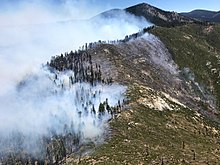
The Schaeffer fire is a wildfire currently burning in Kern River Ranger District of the Sequoia National Forest in Tulare County, California. Determined to have caused by a lightning strike on June 24, the fire crept through the old burn area of the 2002 McNally fire burn area for several days before growing to over 580 acres on June 28.[2] Since then, the fire has ballooned to over 11,750 acres (4,760 ha) in size and is rapidly burning in a north-easterly direction.[1] There is an estimate of only 10 percent containment on the Schaeffer fire as of July 7.
Events
Reported, Saturday, June 24, at approximately 4:16 p.m., the soon to be named Sacheffer fire was noted to be burning in whitethorn, dead and down logs and needle cast.[1]As smoke from the fire has been seen all throughout the Lake Isabella area, the fire, which is burning at about 7,300 feet in elevation, has caused the San Joaquin Valley Air Pollution Control District to alert a smoke advisory in the area.[3] The fire is burning near the community of Kennedy Meadows in the Sequoia National Forest, however it was not threatening any structures at this time.[3]
On Saturday, July 1, the fire made significant runs to the north, creating a smoke column that could be seen from all around the Tulare County area as the fire expanded to over 2,100 acres.[1]
In the first 6 days of July, the fire quadrupled in size. Fueled by low humidity and gusty winds, the fire grew to 11,750 acres by July 7th.
See also
References
- ^ a b c d "Schaeffer Fire". InciWeb. Retrieved June 19, 2017.
- ^ "Schaeffer Fire Announcement". InciWeb. Retrieved June 28, 2017.
- ^ a b Rodriguez-Delgado, Cresencio. "A lightning strike started a fire. Now dangerous smoke has reached this community". The Fresno Bee. Retrieved 28 June 2017.

