Erumely: Difference between revisions
Rinuthomas90 (talk | contribs) |
|||
| Line 168: | Line 168: | ||
===Airport=== |
===Airport=== |
||
[[Cochin International Airport]] (119 km) and [[Thiruvananthapuram]] Airport (140 km) are the nearest airports. Believers Church informed Pinarayi the consent to hand over land for Sabarigiri International airport. The airport at Cheruvally is approved by both governments and may expect to start soon.<ref>http://english.mathrubhumi.com/news/kerala/centre%E2%80%99s-stance-on-proposed-erumeli-airport-favourable-cm-kerala-sabarimala-ashok-gajapathi-raju--1.1509065</ref> |
[[Cochin International Airport]] (119 km) and [[Thiruvananthapuram]] Airport (140 km) are the nearest airports. Believers Church informed Pinarayi the consent to hand over land for Sabarigiri International airport. The airport at Cheruvally is approved by both governments and may expect to start soon.<ref>http://english.mathrubhumi.com/news/kerala/centre%E2%80%99s-stance-on-proposed-erumeli-airport-favourable-cm-kerala-sabarimala-ashok-gajapathi-raju--1.1509065</ref> |
||
On 19th of July 2017, the Kerala Government has announced the construction of Airport at Cheruvally Estate of Harrisons Plantations near Erumely, to facilitate travel of Sabarimala pilgrims<ref>{{cite news|title=Airport For Sabarimala To Come Up at Cheruvally Estate|url=http://www.ndtv.com/kerala-news/airport-for-sabarimala-to-come-up-at-cheruvally-estate-pinarayi-vijayan-1726935|agency=ndtv.com}}</ref>. |
|||
===Proposed airport=== |
===Proposed airport=== |
||
Revision as of 06:28, 22 July 2017
Erumely/Erumeli
എരുമേലി Erumakkolli | |
|---|---|
Town/village | |
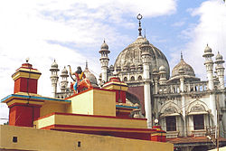
 Erumely Vavar masjid with arch gate of Petta Sastha temple | |
| Nickname(s): Gateway to Sabarimala, Land of religious harmony | |
| Coordinates: 9°28′16″N 76°45′54″E / 9.4710933°N 76.7650384°E | |
| Country | |
| State | Kerala |
| District | Kottayam |
| Government | |
| • Type | Panchayath |
| • Body | Erumely grama panchayath |
| Area | |
• Total | 82.35 km2 (31.80 sq mi) |
| Elevation | 68 m (223 ft) |
| Population (2011) | |
• Total | 43,437 |
| • Density | 530/km2 (1,400/sq mi) |
| Languages | |
| • Official | Malayalam |
| Time zone | UTC+5:30 (IST) |
| PIN | 686509 |
| Telephone code | 04828 |
| Vehicle registration | KL-34 (Kanjirappally Sub RTO) |
| Nearest cities | Kanjirappally |
| Lok Sabha constituency | Pathanamthitta |
| Literacy | 94% |
| Sex ratio | 1049♂/♀ |
| Website | [2] |
Erumely (Template:Lang-ml), also spelt "Erumeli" is a village and town in the southeast part of Kottayam district in Kerala state, India. It is situated on the way to Sabarimala and also an important halting place (idathavalam) for the Sabarimala piligrims. Erumely is famed for its religious harmony and prosperity between Hindus and Muslims which existed from the early periods. It is a place which have strong roots in legends and myths associated with lord Ayyappa.
Etymology
Erumely is the name extracted from Erumakolli ("killed the buffalo"). A myth tells that Lord Ayyappa killed "Mahishi" in this place on the way to collect a tiger's milk. Mahish means buffalo and "Eruma" in Malayalam and hence the name extract "erumakolli".
Location
Erumely is on the Kanjirappally - Pathanamthitta Route. A small river, Koratty (originally known as Manimala River), marks the entrance of Erumely town, which is exactly 14 km from Mundakayam, the gate of Highrange area. World Malayalee association has chosen Erumely as one of the three places in kottayam and pathanamthitta to set up the fifth airport in kerala and proposal is pending for approval. Perunthenaruvi Falls, the scenic waterfall near Vechoochira is located about 13 km (8.1 mi) from Erumely. Cheruvally estate also provides a great experience.
Demographics
As of 2011[update] India census, Erumely had a population of 38890 in which 21199 are males and 22230 are females. Average sex ratio is 1049, which is lower than the state average of 1084. The literacy rate of males is 97.53% and 95.71% for females.[1]
Administration
The panchayath of Erumely was formed in August 15, 1953. It spreads over an area of 82.36 km² with 40% of forest coverage. It is surrounded by Parathodu, Kanjirappally and Mundakkayam panchayaths in north, Chittar panchayath in east and south, Manimala, Chirakkadavu panchayaths in west.[2] The panchayath is divided into 23 wards for its administrative convenience.
Wards in Erumely panchayath
| Pazhayidom | Chenappady |
| Kizhakkekkara | Cheruvally estate |
| Ozhakkanadu | Vazhakkala |
| Nerchappara | Karisseri |
| Kanamala | Umikkuppa |
| Mukkoottuthara | Muttappally |
| Elivalikkara | Propose |
| Pambavalley | Erumely town |
| Poriyan mala | Kanakappalam |
| Sreenipuram | Anglevalley |
| Irumpoonnikkara | Thumarampara |
Economy
The majority of the people are farmers (the town is surrounded by rubber tree plantations) or are in business. Before it was a small town, now its undergoing developments, because of the temple, Masjid and its integrated, non-discriminatory society.
Culture and customs

Erumley has its own culture and it is different from all other places with simplicity and unity of Syrian Christian, Hindu, and Muslim communities. The agrarian regions surrounding the town have a large presence of Catholic - Syrian Christians, who are mainly into rubber cultivation. Hindus and Muslims are found mostly in the town area.
All Hindus who are undertaking Sabarimala pilgrimage visit this place. There are two temples in this town of Lord Ayyappa and the famous "Petta Thullal" (ritual dance) is done in November, December and January months. Erumely Nainar Masjid is situated opposite to Erumely Cheriya Ambalam. Ayyaapan devotees visits Vavar Swamy at Nainar Masjid before visiting Ayyappa Swami. Vavar is considered as the companion of Ayyappa. Devotees believe that Vavar swami is at the masjid. Devotes goes to Cheriya Ambalam from the masjid. Then they will go to the Valiya Ambalam to seek the bleszings of Ayyappa. The visit to Vavar Swamy and Valiyambalam is done in the form a dance known as Pettathulal. This is done by coloring self, holding wooden bows and arrows. The myth is that during the killing of Mahishi, the local tribals had helped Ayyapa Swamy and after the killing, they danced in joy. Pettathulal represents the joy amongst the people. At the end of the Ayyappa season there is festival called Pettathullal where people from Ambalapuzha and Aalangattu will perform this. Ambalapuzha goes first and they will move to the Valiyambalam as usual. The Aalangattu will start this after the 'Krishnaparunth' and star is seen.
Important festivals
Erumely Pettathullal
The "Pettathullal" or ritual dance associated with the killing of the demoness Mahishi, hosted in the Malayalam months of Vrishikam and Dhanu (December and January) is the most noted festival in Erumely.
Chandanakkudam
This is another important festival which is conducted as a preliminary event to the historic pettathullal. The festival starts from the mosque with the "Malisa" procession.
Climate
The climate of Erumely is classified under Köppen. The place remains humid throughout the year with an annual temperature of 31 °C. Among the months, March and April are the hottest. The south west monsoon arrives from mid May to August providing significant amount of rainfall. The average annual rainfall here is 2620 mm. Winter normally starts from December to February.
| Climate data for Erumely, Kerala | |||||||||||||
|---|---|---|---|---|---|---|---|---|---|---|---|---|---|
| Month | Jan | Feb | Mar | Apr | May | Jun | Jul | Aug | Sep | Oct | Nov | Dec | Year |
| Mean daily maximum °C (°F) | 31.1 (88.0) |
31.9 (89.4) |
33.2 (91.8) |
33.3 (91.9) |
32.7 (90.9) |
30.6 (87.1) |
30.0 (86.0) |
30.0 (86.0) |
30.6 (87.1) |
30.3 (86.5) |
30.1 (86.2) |
30.5 (86.9) |
31.2 (88.2) |
| Mean daily minimum °C (°F) | 22.1 (71.8) |
22.8 (73.0) |
24.4 (75.9) |
25.2 (77.4) |
25.2 (77.4) |
24.1 (75.4) |
23.6 (74.5) |
23.7 (74.7) |
23.8 (74.8) |
23.6 (74.5) |
23.3 (73.9) |
22.3 (72.1) |
23.7 (74.6) |
| Average precipitation mm (inches) | 22 (0.9) |
39 (1.5) |
68 (2.7) |
157 (6.2) |
254 (10.0) |
454 (17.9) |
466 (18.3) |
328 (12.9) |
240 (9.4) |
320 (12.6) |
211 (8.3) |
61 (2.4) |
2,620 (103.1) |
| Source: Climate-Data.org[3] | |||||||||||||
Religions
Erumely is the gateway to Sabarimala. One of the important temples at Erumely is Sree Dharmashastha temple. Vavar masjid is also located very near to Sree Dharmashastha temple. Assumption Forane church, under the Syro Malabar Catholic diocese of Kanjirapally, one of the major churches in Kottayam district, is also located here.
Places of worship

- Sree Dharmasastha temple: This temple is located 0.5 km from Erumely town and it is commonly known as Valiyambalam. It is an important meeting place of Ayyappa devotees at times of Mandala - Makaravilakku period.

- Petta Sree Dharmasastha temple: Petta Sastha temple is adjacent to the famous Vavar Masjid at Erumely. Lord Ayyappa presides here in the form of Pettayil Sastha.[4]

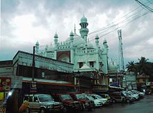
- Vavar Masjid: The masjid at Erumely dedicated to Vavarswami is the most noted landmark of the place.[5] Every pilgrim who comes here visits the masjid to seek the blessings of Vavarswami.
Educational institutions
St. Thomas H.S.S, Devasom Board H.S.S, Vavar Memorial H.S.S, and MT High School are the well known higher secondary schools in Erumely. St. Thomas H.S.S is the oldest school which was started 60 years ago, and is under the Erumely Forane Church.Nirmala Public School, Sher Mount Public School are the schools without higher secondary studies. MES College, on the way to Mukkoottuthara and Sher Mount College of Arts and Commerce which is located 2 km away from Erumely town. Both colleges are affiliated to Mahatma Gandhi University, Kottayam. Assissi Hospital and Nursing College is also at Mukkoottuthara. Amaljyothy Engineering College, under the Syro Malabar Catholic diocese of Kanjirapally, is in nearby Koovappally.
Access
Road
Erumely can be approached through Mundakkayam, Kanjirappally, Manimala,Kanamala, Ponkunnam,Vechoochira , or Ranni. People coming from Kottayam can reach through Kanjirappally.People coming from Kochi can reach through Thripunithura, Pala, Ponkunnam. People from the Highranges can access Erumely through Mundakkayam - Erumely state highway. From the capital city Trivandrum, Erumely is accessed through Ranni. NH220 National Highway passes 10 km near to Erumely through 26th mile, which makes it reachable easily.
Railway
Nearest Rail Heads are Kottayam, Chengannur, Changanassery, and Thiruvalla.
Airport
Cochin International Airport (119 km) and Thiruvananthapuram Airport (140 km) are the nearest airports. Believers Church informed Pinarayi the consent to hand over land for Sabarigiri International airport. The airport at Cheruvally is approved by both governments and may expect to start soon.[6]
On 19th of July 2017, the Kerala Government has announced the construction of Airport at Cheruvally Estate of Harrisons Plantations near Erumely, to facilitate travel of Sabarimala pilgrims[7].
Proposed airport
State and central governments have approved an airport for Sabarimala and Cheruvally estate near Erumely is one among three sites. The other sites were government sites and Cheruvally was announced as government land by court. The case is in court. Airport work may commence soon. It will be a green field airport with no industries or commercial building allowed with a huge radius.The name of the proposed airport is "SABARIGIRI International Airport Pvt LTD". Or shortened as "SABARIGIRI AIRPORT". The official website of the airport is www.sabarigiriairport.in
Distances from various places
- From Kottayam: 50 km
- From Cochin : 98 km
- From Kumily: 70 km
- From Kanjirappally : 14 km
- From Pala : 40 km
- From Mundakkayam : 13.5 km
- From Ranni : 18 km
- From Angamoozhy : 28 km
- From Alappuzha: 73 km
- From Manimala: 17 km
- From Thodupuzha: 63 km
Nearby places
- Mundakayam
- Ranni
- Thulappally
- Kanjirappally
- Kuruvamoozhy
- Chenappady
- Mukkoottuthara
- Ponkunnam
- Kanamala
See also
References
- ^ "Erumeli South Population - Kottayam, Kerala". www.census2011.co.in. Retrieved 2016-11-25.
- ^ "Through Erumely panchayath". lsgkerala.in. Retrieved 2016-11-25.
- ^ "CLIMATE: ERUMELY", Climate-Data.org. Web: [1].
- ^ Sree, Ayyappan (2001). Edathavalams - Sabarimala pilgrimage. Pattom, Trivandrum: Siso books. p. 92. ISBN 817797033X.
- ^ "Erumely Vavar mosque". www.keralatrips.co.in. Retrieved 2016-11-25.
- ^ http://english.mathrubhumi.com/news/kerala/centre%E2%80%99s-stance-on-proposed-erumeli-airport-favourable-cm-kerala-sabarimala-ashok-gajapathi-raju--1.1509065
- ^ "Airport For Sabarimala To Come Up at Cheruvally Estate". ndtv.com.


