Autonomous Region of Príncipe: Difference between revisions
JJMC89 bot (talk | contribs) Migrate {{Infobox settlement}} coordinates parameters to {{Coord}}, see Wikipedia:Coordinates in infoboxes |
|||
| Line 92: | Line 92: | ||
* [http://www.h-net.org/reviews/showrev.php?id=39831 Histórias da Ilha do Príncipe] |
* [http://www.h-net.org/reviews/showrev.php?id=39831 Histórias da Ilha do Príncipe] |
||
{{Pagué}} |
|||
{{STP-districts}} |
{{STP-districts}} |
||
Revision as of 09:05, 29 July 2017
Príncipe | |
|---|---|
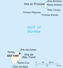
 Map of São Tomé and Príncipe with Príncipe near the top | |
| Coordinates: 1°37′N 7°24′E / 1.617°N 7.400°E | |
| Country | |
| Capital | Santo António |
| Area | |
• Total | 142 km2 (55 sq mi) |
| Elevation | 948 m (3,110 ft) |
| Population (2012) | |
• Total | 7,542 |
| • Density | 53/km2 (140/sq mi) |
| Time zone | UTC+0 |
| Area code | 00239-19x-xxxx? |
| ISO 3166 code | ST-P |
Príncipe Province is one of the two provinces of São Tomé and Príncipe. Since 1995 has been an autonomous region of the twin island republic of São Tomé and Príncipe. The province includes several small uninhabited islands around the island of Príncipe. The Obo National Park covers the part of the area. Principe province has a school or collegiates (colegio), a lyceum (middle schools), churches, beaches, a port and a few squares (praças).
Districts
Pagué District is the only district in the province.
Islands
The main island is Príncipe. Others are:
History
Príncipe’s discovery by Portuguese navigators. Initially the hitherto uninhabited island was baptized Santo Antão or Santo António de Abade, the Catholic saint’s day of January 17, the date the island was discovered. Later the island was renamed Príncipe in homage to Prince Dom João--later King João II (1481-95)--who was entitled to the taxes levied on the sugar produced on the island. Príncipe’s settlement by Portuguese colonists and African slaves began in 1500 when the island was granted to the donatary António Carneiro, whose family possessed it for more than 250 years. After the decline of the sugar industry in the early seventeenth century until the mid-nineteenth century, the production of food for the provision of ships and the slave trade dominated the island’s economy. In 1753, Príncipe reverted to the Crown when, due to the political instability in São Tomé, the archipelago’s capital was transferred to its main settlement Santo António that at the same time was granted city rights. Despite its new status, Santo António always remained a small town with poorly developed infrastructures. During the hundred years that it remained the capital it did not even provide an official residence for the governor, who, consequently, relied on private accommodation. Until 1965 there was not a single tarred road in Príncipe. Only during the reign of Governor Silva Sebastião (1963-72), when the armed struggle in Angola, Portuguese Guinea, and Mozambique had already commenced and Portugal started to invest more in the development of her colonies, Príncipe started benefiting from the various public works programs. In the second half of the 1960s, three tarred roads, a tarred airstrip, and a new primary school were constructed in Príncipe. After São Tomé and Príncipe’s independence in 1975, however, the smaller island continued to feel the adverse consequences of its double insularity. In December 1981, a lack of food supplies provoked a revolt against the government in São Tomé, which was accompanied by secessionist slogans. In 1995, a few years after the country’s democratic transition, Príncipe became an autonomous region. The island’s first regional government was elected in the same year. The central government’s failure to hold any local election in the years thereafter caused another popular protest in June 2006 that forced Príncipe’s regional government to step down.
Settlements
Príncipe has one town, Santo António, and an airport (IATA code: PCP, ICAO: FPPR), as well as some villages including Bela Vista, Bombom, Futuro, Neves Ferreira, Paciencia, Ponta Fonte, Ribeira Ize, Santo António de Ureca and Vila Rosa. Few of them are connected to the small road network. One of the few improvements was the establishment of a regular flight connection with São Tomé, in 1949.
Demographics
Besides the official language of Portuguese, a local tongue called Principense or Lunguyê and, in some scale, Forro are also spoken. In 1771, Príncipe had a population of 5,850: 111 whites, 165 free mulattoes, 6 mulatto slaves, 900 free blacks, and 4,668 black slaves. In 1875, the year when slavery was officially abolished in the archipelago, Príncipe’s population had dropped to only 1,946, of whom 45 were Europeans, 1,521 were free natives, and 380 were freemen.


