Alentejo Litoral: Difference between revisions
Appearance
Content deleted Content added
Rescuing 0 sources and tagging 1 as dead. #IABot (v1.2.4) |
Rescuing 1 sources and tagging 0 as dead. #IABot (v1.5.2) (Josve05a) |
||
| Line 1: | Line 1: | ||
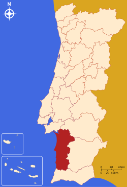
[[Image:LocalNUTS3AlentejoLitoral.svg|thumb|250px|right|Map showing the location of the Alentejo Litoral subregion.]] |
[[Image:LocalNUTS3AlentejoLitoral.svg|thumb|250px|right|Map showing the location of the Alentejo Litoral subregion.]] |
||
The '''[[Intermunicipal communities of Portugal|Comunidade Intermunicipal]] do Alentejo Litoral''' is an administrative division in [[Portugal]]. It was created in May 2009.<ref>[http://www.cimal.pt/index.php?option=com_content&view=article&id=46&Itemid=54 CIM Alentejo Litoral]</ref> It is also a [[NUTS3]] subregion of the [[Alentejo Region]]. The seat of the intermunicipal community is [[Grândola]]. Alentejo Litoral comprises municipalities of both the [[Beja District]] and the [[Setúbal District]]. The population in 2011 was 97,925,<ref name=ine>[http://www.ine.pt/xportal/xmain?xlang=en&xpid=INE&xpgid=ine_indicadores&indOcorrCod=0005889&contexto=pi&selTab=tab0 Instituto Nacional de Estatística]</ref> in an area of 5,309.41 km².<ref name=dgt>[http://www.dgterritorio.pt/ficheiros/cadastro/caop/caop_download/caop_2014_0/areasfregmundistcaop2014_2 Direção-Geral do Território]{{dead link|date=October 2016 |bot=InternetArchiveBot |fix-attempted=yes }}</ref> |
The '''[[Intermunicipal communities of Portugal|Comunidade Intermunicipal]] do Alentejo Litoral''' is an administrative division in [[Portugal]]. It was created in May 2009.<ref>[http://www.cimal.pt/index.php?option=com_content&view=article&id=46&Itemid=54 CIM Alentejo Litoral] {{webarchive|url=https://web.archive.org/web/20140819084819/http://www.cimal.pt/index.php?option=com_content&view=article&id=46&Itemid=54 |date=2014-08-19 }}</ref> It is also a [[NUTS3]] subregion of the [[Alentejo Region]]. The seat of the intermunicipal community is [[Grândola]]. Alentejo Litoral comprises municipalities of both the [[Beja District]] and the [[Setúbal District]]. The population in 2011 was 97,925,<ref name=ine>[http://www.ine.pt/xportal/xmain?xlang=en&xpid=INE&xpgid=ine_indicadores&indOcorrCod=0005889&contexto=pi&selTab=tab0 Instituto Nacional de Estatística]</ref> in an area of 5,309.41 km².<ref name=dgt>[http://www.dgterritorio.pt/ficheiros/cadastro/caop/caop_download/caop_2014_0/areasfregmundistcaop2014_2 Direção-Geral do Território]{{dead link|date=October 2016 |bot=InternetArchiveBot |fix-attempted=yes }}</ref> |
||
==Municipalities== |
==Municipalities== |
||
Revision as of 21:46, 13 September 2017

The Comunidade Intermunicipal do Alentejo Litoral is an administrative division in Portugal. It was created in May 2009.[1] It is also a NUTS3 subregion of the Alentejo Region. The seat of the intermunicipal community is Grândola. Alentejo Litoral comprises municipalities of both the Beja District and the Setúbal District. The population in 2011 was 97,925,[2] in an area of 5,309.41 km².[3]
Municipalities
It is composed of five municipalities:[4]
| Municipality | Population (2011)[2] | Area (km²)[3] |
|---|---|---|
| Alcácer do Sal | 13,046 | 1499.87 |
| Grândola | 14,826 | 825.94 |
| Odemira | 26,066 | 1720.60 |
| Santiago do Cacém | 29,749 | 1059.69 |
| Sines | 14,238 | 203.30 |
| Total | 97,925 | 5,309.41 |
References
- ^ CIM Alentejo Litoral Archived 2014-08-19 at the Wayback Machine
- ^ a b Instituto Nacional de Estatística
- ^ a b Direção-Geral do Território[permanent dead link]
- ^ "Law nr. 75/2013" (pdf). Diário da República (in Portuguese). Assembly of the Republic (Portugal). Retrieved 14 August 2014.
External links
Wikivoyage has a travel guide for Alentejo Litoral.
