North University Park, Los Angeles: Difference between revisions
→Geography: adding one more street sign location |
Removing banner as almost every sentence has a citation. |
||
| Line 1: | Line 1: | ||
{{more footnotes|date=September 2017}} |
|||
{{Infobox settlement |
{{Infobox settlement |
||
|name=North University Park |
|name=North University Park |
||
Revision as of 18:25, 14 September 2017
North University Park | |
|---|---|
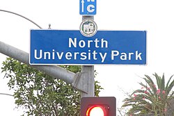
 North University Park signage located at the intersection of Vermont Avenue and Adams Boulevard | |
| Coordinates: 34°1′48″N 118°17′20″W / 34.03000°N 118.28889°W | |
| Country | |
| State | |
| County | |
| Time zone | Pacific |
| Zip Code | 90007 |
| Area code | 213 |
North University Park is a neighborhood in Los Angeles, California. It contains two historic districts that are both on the National Register of Historic Places: The North University Park Historic District and the Menlo Avenue–West Twenty-ninth Street Historic District.[1]
Geography
North University Park is bounded between Vermont Avenue on the West, Figueroa Street on the East, Adams Boulevard on the North and Jefferson Boulevard on the South. [1]
The City of Los Angeles has installed North University Park signage at the intersection of Adams Boulevard and Figueroa Street [2], Adams Boulevard and Vermont Avenue [3], Jefferson Boulevard and Vermont Avenue, [4], and Jefferson Boulevard and Figueroa Street.[5]
History
Located just north of USC's campus, North University Park was agricultural land until the late nineteenth century. Today, the neighborhood features one of the richest collections of historic architecture in the city of Los Angeles, including Victorian and Craftsman homes dating back to the 1800s.[1]
National Register of Historic Places
There are two Historic Districts in North University Park.
The Menlo Avenue–West Twenty-ninth Street Historic District is bounded by West Adams Boulevard on the north, Ellendale on the east, West Thirtieth Street on the south, and Vermont Avenue to the west. The district was added to the National Register of Historic Places in 1987.[6]
The North University Park Historic District is bounded by West Adams Boulevard on the north, Magnolia Avenue on the west, Hoover Street on the east, and 28th Street on the south. The district was added to the National Register of Historic Places in 2004.[7]
North University Park Specific Plan
Within North University Park is the city designated "North University Park Specific Plan". [8] The Specific Plan applies to the area between Vermont Avenue on the West, Hoover Street on the East, Adams Boulevard on the North and 30th Place on the South. The purpose of the Specific Plan is to regulate floor area ratios, the use of land and buildings, height and bulk of buildings, architectural and landscape treatment, signs, and vehicular and pedestrian circulation.
Media
Annalise Keating’s Victorian Home from the television show How to Get Away With Murder is located in North University Park at 1130 W. 27th Street (27th Street at Monmouth Ave). [9]
References
- ^ a b c Charles Epting (2 July 2013). University Park, Los Angeles: A Brief History. Arcadia Publishing Incorporated. pp. 67–. ISBN 978-1-62584-028-8.
- ^ https://www.google.com/maps/@34.0281392,-118.2760664,3a,75y,225.52h,93.45t/data=!3m6!1e1!3m4!1s_dbns2RF0BTwHgiajAOh9w!2e0!7i13312!8i6656
- ^ https://www.google.com/maps/@34.0326855,-118.2916561,3a,37.5y,89.89h,90.05t/data=!3m6!1e1!3m4!1sH9Bi1F3xne2wBNEy_aRMQQ!2e0!7i13312!8i6656
- ^ https://www.google.com/maps/@34.0255427,-118.291475,3a,75y,359.32h,82.54t/data=!3m7!1e1!3m5!1senEo5EPI4Zh5jgm__Ly0uw!2e0!6s%2F%2Fgeo1.ggpht.com%2Fcbk%3Fpanoid%3DenEo5EPI4Zh5jgm__Ly0uw%26output%3Dthumbnail%26cb_client%3Dsearch.TACTILE.gps%26thumb%3D2%26w%3D86%26h%3D86%26yaw%3D87.110085%26pitch%3D0%26thumbfov%3D100!7i13312!8i6656
- ^ https://www.google.com/maps/@34.0220044,-118.279981,3a,75y,297.89h,92.13t/data=!3m7!1e1!3m5!1sg69-98m_0OBJQzniNI5D8Q!2e0!6s%2F%2Fgeo3.ggpht.com%2Fcbk%3Fpanoid%3Dg69-98m_0OBJQzniNI5D8Q%26output%3Dthumbnail%26cb_client%3Dsearch.TACTILE.gps%26thumb%3D2%26w%3D86%26h%3D86%26yaw%3D266.26855%26pitch%3D0%26thumbfov%3D100!7i13312!8i6656
- ^ https://npgallery.nps.gov/AssetDetail/NRIS/87000139
- ^ https://npgallery.nps.gov/AssetDetail/NRIS/04000016
- ^ https://planning.lacity.org/complan/specplan/pdf/nunipark.pdf
- ^ http://www.seeing-stars.com/Locations/HowToGetAwayWithMurder.shtml

