Noordwolde, Friesland: Difference between revisions
Appearance
Content deleted Content added
|topic=geo |
No edit summary |
||
| Line 1: | Line 1: | ||
{{Expand West Frisian|topic=geo|date=December 2008|Noardwâlde (Weststellingwerf)}} |
{{Expand West Frisian|topic=geo|date=December 2008|Noardwâlde (Weststellingwerf)}} |
||
{{Infobox settlement |
{{Infobox settlement |
||
| |
| name = Noordwolde |
||
| |
| native_name = Noardwâlde |
||
| native_name_lang = <!-- ISO 639-2 code e.g. "fr" for French. If more than one, use {{lang}} instead --> |
|||
|mapsize = 280px |
|||
| settlement_type = Village |
|||
|subdivision_type = Country |
|||
| image_skyline = Noordwolde NH kerk.jpg |
|||
|subdivision_name = {{flagicon|Netherlands}} [[Netherlands]] |
|||
| image_alt = |
|||
|subdivision_type1 = Province |
|||
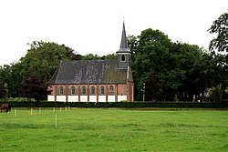
| image_caption = Noordwolde Church |
|||
|subdivision_name1 = {{flagicon|Friesland}} [[Friesland]] |
|||
| image_flag = |
|||
|settlement_type = Village |
|||
| flag_alt = |
|||
|population_total = c. 3790 |
|||
| image_seal = |
|||
| seal_alt = |
|||
| image_shield = |
|||
| shield_alt = |
|||
| etymology = |
|||
| nickname = |
|||
| motto = |
|||
| image_map = Map NL Weststellingwerf Noardwâlde.png |
|||
| map_alt = |
|||
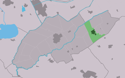
| map_caption = Location in Weststellingwerf municipality |
|||
| pushpin_map = Netherlands<!-- the name of a location map as per http://en.wikipedia.org/wiki/Template:Location_map --> |
|||
| pushpin_label_position = right |
|||
| pushpin_mapsize = 250 |
|||
| pushpin_map_caption = Location in the Netherlands |
|||
| coordinates = {{coord|52|53|29|N|6|8|32|E|display=title|region:NL_type:city_source:nlwiki}} |
|||
| coor_pinpoint = |
|||
| coordinates_footnotes = |
|||
| subdivision_type = Country |
|||
| subdivision_name = {{flagicon|Netherlands}} [[Netherlands]] |
|||
| subdivision_type1 = [[Provinces of the Netherlands|Province]] |
|||
| subdivision_name1 = {{flagicon|Friesland}} [[Friesland]] |
|||
| subdivision_type2 = [[List of municipalities of the Netherlands|Municipality]] |
|||
| subdivision_name2 = {{flagicon|Weststellingwerf}} [[Weststellingwerf]] |
|||
| subdivision_type3 = |
|||
| subdivision_name3 = |
|||
| established_title = |
|||
| established_date = |
|||
| founder = |
|||
| seat_type = |
|||
| seat = |
|||
| government_footnotes = |
|||
| leader_party = |
|||
| leader_title = |
|||
| leader_name = |
|||
| unit_pref = Metric |
|||
<!-- ALL fields with measurements have automatic unit conversion --> |
|||
<!-- for references: use <ref> tags --> |
|||
| area_footnotes = |
|||
| area_urban_footnotes = <!-- <ref> </ref> --> |
|||
| area_rural_footnotes = <!-- <ref> </ref> --> |
|||
| area_metro_footnotes = <!-- <ref> </ref> --> |
|||
| area_magnitude = <!-- <ref> </ref> --> |
|||
| area_note = |
|||
| area_water_percent = |
|||
| area_rank = |
|||
| area_blank1_title = |
|||
| area_blank2_title = |
|||
<!-- square kilometers --> |
|||
| area_total_km2 = |
|||
| area_land_km2 = |
|||
| area_water_km2 = |
|||
| area_urban_km2 = |
|||
| area_rural_km2 = |
|||
| area_metro_km2 = |
|||
| area_blank1_km2 = |
|||
| area_blank2_km2 = |
|||
<!-- hectares --> |
|||
| area_total_ha = |
|||
| area_land_ha = |
|||
| area_water_ha = |
|||
| area_urban_ha = |
|||
| area_rural_ha = |
|||
| area_metro_ha = |
|||
| area_blank1_ha = |
|||
| area_blank2_ha = |
|||
| length_km = |
|||
| width_km = |
|||
| dimensions_footnotes = |
|||
| elevation_footnotes = |
|||
| elevation_m = |
|||
| population_as_of = January 2017 |
|||
| population_footnotes = |
|||
| population_total = 3596 |
|||
| population_density_km2 = auto |
|||
| population_note = |
|||
| population_demonym = |
|||
| timezone1 = |
|||
| utc_offset1 = |
|||
| timezone1_DST = |
|||
| utc_offset1_DST = |
|||
| postal_code_type = Postal code |
|||
| postal_code = |
|||
| area_code_type = |
|||
| area_code = |
|||
| iso_code = |
|||
| website = [http://www.noordwolde.me/ Website about Noordwolde] |
|||
| footnotes = |
|||
}} |
}} |
||
'''Noordwolde''' ({{lang-fry|Noardwâlde}}) is a village in [[Weststellingwerf]] in the province of [[Friesland]], the [[Netherlands]]. It had a population of around |
'''Noordwolde''' ({{lang-fry|Noardwâlde}}) is a village in [[Weststellingwerf]] in the province of [[Friesland]], the [[Netherlands]]. It had a population of around 3,600 as of 2017.<ref>[https://www.weststellingwerf.nl/ontdek-weststellingwerf/kerngegevens-gemeente-weststellingwerf_41292/ Villages] - Weststellingwerf municipality {{nl|icon}}</ref> |
||
There is a restored [[windmill]] in the village, [[Windlust, Noordwolde|''Windlust'']]. |
|||
The National Museum of Weaving is located in the village. |
The National Museum of Weaving is located in the village. |
||
There is a natural lake, the Spokedam, which is partly surrounded by a beach, on the outskirts of Noordwolde. There are several camp sites near the lake such as "Hanestede" and the bungalow park "The Bosmeer". |
There is a natural lake, the Spokedam, which is partly surrounded by a beach, on the outskirts of Noordwolde. There are several camp sites near the lake such as "Hanestede" and the bungalow park "The Bosmeer". |
||
| Line 17: | Line 106: | ||
the largest model train shop (G-scale) in Europe is in Noordwolde. |
the largest model train shop (G-scale) in Europe is in Noordwolde. |
||
==References== |
|||
{{Reflist}} |
|||
==External links== |
==External links== |
||
{{commonscat-inline|Noordwolde, Friesland}} |
{{commonscat-inline|Noordwolde, Friesland}} |
||
* [http://www.noordwolde.me/ Website over Noordwolde] |
|||
* [http://www.blikopweststellingwerf.nl/ Noordwolde en de gemeente Weststellingwerf, plaatselijk nieuws] |
* [http://www.blikopweststellingwerf.nl/ Noordwolde en de gemeente Weststellingwerf, plaatselijk nieuws] |
||
{{coord|52|53|29|N|6|8|32|E|display=title|region:NL_type:city_source:nlwiki}} |
|||
[[Category:Populated places in Friesland]] |
[[Category:Populated places in Friesland]] |
||
Revision as of 14:16, 1 October 2017
You can help expand this article with text translated from the corresponding article in Western Frisian. (December 2008) Click [show] for important translation instructions.
|
Noordwolde
Noardwâlde | |
|---|---|
Village | |
 Noordwolde Church | |
 Location in Weststellingwerf municipality | |
| Coordinates: 52°53′29″N 6°8′32″E / 52.89139°N 6.14222°E | |
| Country | |
| Province | |
| Municipality | |
| Population (January 2017) | |
• Total | 3,596 |
| Website | Website about Noordwolde |
Noordwolde (Template:Lang-fry) is a village in Weststellingwerf in the province of Friesland, the Netherlands. It had a population of around 3,600 as of 2017.[1]
There is a restored windmill in the village, Windlust. The National Museum of Weaving is located in the village. There is a natural lake, the Spokedam, which is partly surrounded by a beach, on the outskirts of Noordwolde. There are several camp sites near the lake such as "Hanestede" and the bungalow park "The Bosmeer". There is a swimming pool beside the Spokedam. There are two supermarkets and several other shops and restaurants in the village and the largest model train shop (G-scale) in Europe is in Noordwolde.
References
- ^ Villages - Weststellingwerf municipality Template:Nl
External links
![]() Media related to Noordwolde, Friesland at Wikimedia Commons
Media related to Noordwolde, Friesland at Wikimedia Commons

