Mesones de Isuela: Difference between revisions
Appearance
Content deleted Content added
Add no references tag |
No edit summary |
||
| Line 1: | Line 1: | ||
{{references|date= July 2016}} |
{{references|date= July 2016}} |
||
{{Infobox |
{{Infobox settlement |
||
<!-- See Template:Infobox settlement for additional fields and descriptions --> |
|||
| ⚫ | |||
| type = [[municipalities of Spain|municipality]] |
|||
| ⚫ | |||
nickname = | |
nickname = | |
||
image_flag = Bandera de Mesones de Isuela.svg| |
image_flag = Bandera de Mesones de Isuela.svg| |
||
Revision as of 23:23, 14 November 2017
Mesones de Isuela | |
|---|---|
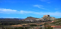
 View of Mesones de Isuela town with the Sierra de Nava Alta in the background and the Moncayo Massif covered in snow in the distance. | |
 | |
| Country | Spain |
| Autonomous community | Aragon |
| Province | Zaragoza |
| Comarca | Comunidad de Calatayud |
| Area | |
• Total | 48 km2 (19 sq mi) |
| Elevation | 513 m (1,683 ft) |
| Population (2004) | |
• Total | 339 |
| • Density | 7.1/km2 (18/sq mi) |
| Time zone | UTC+1 (CET) |
| • Summer (DST) | UTC+2 (CEST) |
Mesones de Isuela, also known as Mesones, is a municipality located in the province of Zaragoza, Aragon, Spain. According to the 2004 census (INE), the municipality has a population of 339 inhabitants.


