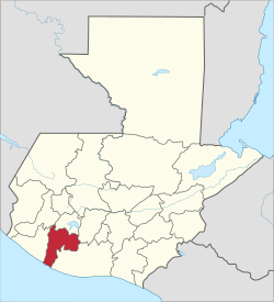
Suchitepéquez Department: Difference between revisions
Appearance
Content deleted Content added
ClueBot NG (talk | contribs) m Reverting possible vandalism by 68.193.211.8 to version by Ljgua124. Report False Positive? Thanks, ClueBot NG. (2756282) (Bot) |
JJMC89 bot (talk | contribs) Remove unrecognized coordinate parameters. Use |coordinates={{coord|...}} instead. See Wikipedia:Coordinates in infoboxes. |
||
| Line 37: | Line 37: | ||
|pushpin_map_caption =Location in Guatemala |
|pushpin_map_caption =Location in Guatemala |
||
<!-- Location ------------------> |
<!-- Location ------------------> |
||
|coordinates = |
|||
|coordinates_display = inline,title |
|||
|coordinates_region = GT |
|||
|subdivision_type = Country |
|subdivision_type = Country |
||
|subdivision_name = [[Image:Flag of Guatemala.svg|25px]] [[Guatemala]] |
|subdivision_name = [[Image:Flag of Guatemala.svg|25px]] [[Guatemala]] |
||
Revision as of 06:06, 9 December 2017
Suchitepéquez | |
|---|---|
Department | |
 Suchitepéquez | |
| Country | |
| Department | Mazatenango |
| Capital | Mazatenango |
| Municipalities | 20 |
| Government | |
| • Type | Departmental |
| Population | |
| • Religions | Roman Catholicism Evangelicalism Maya |
| Time zone | -6 |
Suchitepéquez (Template:IPA-es) is one of the 22 departments of Guatemala. Its capital is Mazatenango. It is situated in the southwestern region of Guatemala, bordering Quetzaltenango, Sololá, and Chimaltenango to the north, the Pacific Ocean to the south, Escuintla to the east, and Retalhuleu to the west.
Municipalities
- Chicacao
- Cuyotenango
- Mazatenango
- Patulul
- Pueblo Nuevo
- Río Bravo
- Samayac
- San Antonio Suchitepéquez
- San Bernardino
- San Francisco Zapotitlán
- San Gabriel
- San José El Idolo
- San Juan Bautista
- San Lorenzo, Suchitepéquez
- San Miguel Panán
- San Pablo Jocopilas
- Santa Bárbara
- Santo Domingo Suchitepequez
- Santo Tomás La Unión
- Zunilito
References
- ^ "XI Censo Nacional de Poblacion y VI de Habitación (Censo 2002)". INE. 2002.
- ^ "Comunidad Lingüística Ch'orti'". Academia de Lenguas Mayas. 2008. Retrieved 2008.
{{cite web}}: Check date values in:|accessdate=(help)
Gall, Francis (1976). Diccionario Geográfico de Guatemala. 4 vols. Guatemala: Instituto Geográfico Nacional. {{cite book}}: Cite has empty unknown parameter: |coauthors= (help)
External links
14°32′02″N 91°30′11″W / 14.534°N 91.503°W


