Buk District, Busan: Difference between revisions
Appearance
Content deleted Content added
Narky Blert (talk | contribs) dab-needed tag |
m Disambiguating links to BTS (link removed) using DisamAssist. |
||
| Line 53: | Line 53: | ||
==Ancestry== |
==Ancestry== |
||
* [[Jungkook]]: |
* [[Jungkook]]: BTS member |
||
==Sister cities== |
==Sister cities== |
||
Revision as of 13:36, 12 February 2018
Buk
북구 | |
|---|---|
| Korean transcription(s) | |
| • Hanja | 北區 |
| • Revised Romanization | Buk-gu |
| • McCune-Reischauer | Puk-ku |
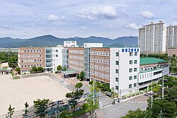
 Hwamyeong High School and surrounding apartments | |
 | |
| Country | South Korea |
| Region | Yeongnam |
| Provincial level | Busan |
| Administrative divisions | 13 administrative dong |
| Area | |
• Total | 38.30 km2 (14.79 sq mi) |
| Population (2005[1]) | |
• Total | 336,753 |
| • Density | 8,793/km2 (22,770/sq mi) |
| • Dialect | Gyeongsang |
| Website | Buk District Office |


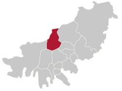
Buk District (literally north district) is a gu, or district, in north central Busan, South Korea. Buk-gu covers a surface of 38.30 km² is home to about 335,000 people. It attained the status of gu in 1978.
Administrative divisions

Buk-gu is divided into 5 legal dong, which altogether comprise 13 administrative dong, as follows:
- Gupo-dong (3 administrative dong)
- Geumgok-dong
- Hwamyeong-dong (3 administrative dong)
- Deckcheon-dong (3 administrative dong)
- Mandeok-dong (3 administrative dong)
Ancestry
- Jungkook: BTS member
Sister cities
See also
References
External links
- Buk-gu website (in English)
35°12′N 128°59′E / 35.2°N 128.99°E

